Flörsbachtal
| Flörsbachtal | ||
|---|---|---|

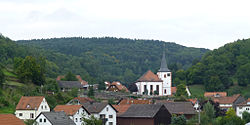
Flörsbachtal, Ortsteil Lohrhaupten
|
||
|
||
| Coordinates: 50°07′N 09°26′E / 50.117°N 9.433°ECoordinates: 50°07′N 09°26′E / 50.117°N 9.433°E | ||
| Country | Germany | |
| State | Hesse | |
| Admin. region | Darmstadt | |
| District | Main-Kinzig-Kreis | |
| Government | ||
| • Mayor | Frank Soer | |
| Area | ||
| • Total | 52.11 km2 (20.12 sq mi) | |
| Population (2015-12-31) | ||
| • Total | 2,343 | |
| • Density | 45/km2 (120/sq mi) | |
| Time zone | CET/CEST (UTC+1/+2) | |
| Postal codes | 63639 | |
| Dialling codes | 06057 | |
| Vehicle registration | MKK, GN, SLÜ | |
| Website | www.floersbachtal.de | |
Flörsbachtal is a municipality in the Main-Kinzig district, in Hesse, Germany. It has a population close to 2,400. Flösbachtal contains both the oldest parish and the youngest settlement established in the Spessart hills. Located within the municipal territory is the Hermannskoppe, the highest elevation in the Hessian part of the Spessart and the Wiesbüttmoor, a rare hanging bog.
The community Flörsbachtal was newly created in 1972 and is named after the Flörsbach, a stream that flows into the Lohrbach, the name of the upper part of the Lohr which flows into the Main at Lohr am Main.
Flörsbachtal is located in the far south of the Main-Kinzig district of Hesse, right next to the state of Bavaria, which surrounds the community on three sides (west, south and east). Flörsbachtal lies in the wooded hills of the Spessart.
Around 75% of the municipal territory is covered by forests. It also includes the nature preserve Wiesbüttmoor, a rare hanging bog and Wiesbüttsee, a small artificial lake created for mining operations, ca. 1760. The moor came into being in the later 18th century as the water dammed at the lake turned the woods upstream into bog land. Until the mid-19th century the surrounding hills, deforested during mining operations, were mostly covered in heather. Today they have been reclaimed by forest. Wiesbüttmoor has been a nature preserve since 1953.
Other locations in Flörsbachtal include the Bergfeld, an agricultural area in a clearing mostly surrounded by forest and the hill Wellersberg. The hill Hermannskoppe, the highest point in the Hessian part of the Spessart and over which runs the Bavarian-Hessian border, is also located in the municipal territory.
...
Wikipedia


