Lohr am Main
| Lohr a. Main | ||
|---|---|---|

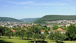
Lohr (left) and Sendelbach (right), viewed from the Lohrer Alm
|
||
|
||
| Coordinates: 50°0′N 09°35′E / 50.000°N 9.583°ECoordinates: 50°0′N 09°35′E / 50.000°N 9.583°E | ||
| Country | Germany | |
| State | Bavaria | |
| Admin. region | Unterfranken | |
| District | Main-Spessart | |
| Government | ||
| • Mayor | Mario Paul (Ind.) | |
| Area | ||
| • Total | 90.44 km2 (34.92 sq mi) | |
| Population (2015-12-31) | ||
| • Total | 15,060 | |
| • Density | 170/km2 (430/sq mi) | |
| Time zone | CET/CEST (UTC+1/+2) | |
| Postal codes | 97816 | |
| Dialling codes | 09352 | |
| Vehicle registration | MSP | |
Lohr am Main (officially: Lohr a.Main) is a town in the Main-Spessart district in the Regierungsbezirk of Lower Franconia (Unterfranken) in Bavaria, Germany and the seat (but not a member) of the Verwaltungsgemeinschaft (municipal association) of Lohr am Main. It has a population of around 15,000.
The town takes its name from the eponymous river that flows into the Main in the municipality. The addition "am Main" distinguishes it from other towns also named Lohr.
Past ways of spelling the name include:
The municipal territory extends on both banks of the Main about halfway between Würzburg and Aschaffenburg in Lower Franconia. The town of Lohr lies on the eastern slope of the Spessart at a bend in the river Main, which swings towards the south here, forming the beginning of the Mainviereck ("Main Square" – the southern part of the Spessart). In Lohr, the river Lohr empties into the Main. Perhaps for its geographical location or the fact that two major valleys lead into the interior of the range, the town is known as the "Gateway to the Spessart" (Tor zum Spessart).
The Main river valley is steep with an elevation change from 160 m above sea level at Gemünden dropping to 100 m above sea level at Hanau. The river Main in its natural state is a fast-moving stream unsuitable for shipping. In the 19th century the river was tamed and a system of dams and locks is now part of the Rhine-Main-Danube Canal connecting the North Sea with the Black Sea.
The bedrock, with a depth of about 400 m, is made up mainly of sedimentary minerals. In the Spessart is found a great deal of bunter. This geological plain with a slight slope to the southeast is the product of a large continental sea that drained owing to a tectonic shift. In the east the range is abutted by the Fränkische Platte (a flat, mostly agricultural region), whose geology is mainly Muschelkalk-based.
...
Wikipedia


