Fitchburg, WI
| Fitchburg, Wisconsin | |
|---|---|
| City | |
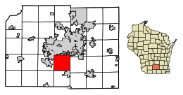
 Location of Fitchburg in Dane County, Wisconsin. |
|
| Coordinates: 43°0′23″N 89°25′53″W / 43.00639°N 89.43139°WCoordinates: 43°0′23″N 89°25′53″W / 43.00639°N 89.43139°W | |
| Country | United States |
| State | Wisconsin |
| County | Dane |
| Area | |
| • Total | 35.21 sq mi (91.19 km2) |
| • Land | 34.97 sq mi (90.57 km2) |
| • Water | 0.24 sq mi (0.62 km2) |
| Population (2010) | |
| • Total | 25,260 |
| • Estimate (2016) | 28,875 |
| • Density | 722.3/sq mi (278.9/km2) |
| Time zone | Central (CST) (UTC-6) |
| • Summer (DST) | CDT (UTC-5) |
| Zipcode | 53711, 53719 |
| Area code(s) | 608 |
| FIPS code | 55-25950 |
| Website | fitchburgwi |
Fitchburg is a city in Dane County, Wisconsin, United States. The population was 25,260 at the 2010 census. Fitchburg is a suburb of Madison and is part of the Madison Metropolitan Statistical Area. Fitchburg consists of a mix of suburban neighborhoods closer the border with the city of Madison, commercial and industrial properties, and more rural properties in the southern portion of the city. Despite its status as an incorporated city, some rural parts of Fitchburg still lack certain municipal services such as sewer, water, and natural gas.
Fitchburg was a town until its incorporation as a city on April 26, 1983. As the city of Madison began to encroach upon the town of Fitchburg via annexation, the town pursued incorporation as a city to halt Madison's expansion into the town. The fight to allow incorporation ultimately went to the Wisconsin State Supreme Court, which ruled that Fitchburg could incorporate as a city.
According to the United States Census Bureau, the city has a total area of 35.21 square miles (91.19 km2), of which, 34.97 square miles (90.57 km2) is land and 0.24 square miles (0.62 km2) is water.
As of 2000 the median income for a household in the city was $50,433, and the median income for a family was $64,106. Males had a median income of $37,440 versus $27,974 for females. The per capita income for the city was $27,317. About 5.0% of families and 6.4% of the population were below the poverty line, including 7.2% of those under age 18 and 6.9% of those age 65 or over.
As of the census of 2010, there were 25,260 people, 9,955 households, and 6,238 families residing in the city. The population density was 722.3 inhabitants per square mile (278.9/km2). There were 10,668 housing units at an average density of 305.1 per square mile (117.8/km2). The racial makeup of the city was 72.2% White, 10.4% African American, 0.4% Native American, 4.9% Asian, 8.8% from other races, and 3.2% from two or more races. Hispanic or Latino of any race were 17.2% of the population.
...
Wikipedia
