Fishkill, New York
| Fishkill, New York | ||
|---|---|---|
| Village | ||

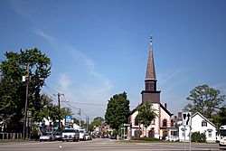
Village entrance on Main Street,
with the First Reformed Church to the right |
||
|
||
 Location of Fishkill, New York |
||
| Coordinates: 41°32′3″N 73°53′57″W / 41.53417°N 73.89917°W | ||
| Country | United States | |
| State | New York | |
| County | Dutchess | |
| Town | Fishkill | |
| Area | ||
| • Total | 0.83 sq mi (2.14 km2) | |
| • Land | 0.82 sq mi (2.12 km2) | |
| • Water | 0.004 sq mi (0.01 km2) | |
| Elevation | 220 ft (67 m) | |
| Population (2010) | ||
| • Total | 2,171 | |
| • Density | 2,646/sq mi (1,021.7/km2) | |
| Time zone | Eastern (EST) (UTC-5) | |
| • Summer (DST) | EDT (UTC-4) | |
| ZIP code | 12524 | |
| Area code(s) | 845 | |
| FIPS code | 36-25967 | |
| GNIS feature ID | 0977519 | |
| Website | vofishkill |
|
Fishkill is a village within the town of Fishkill in Dutchess County, New York, United States. The village population was 2,171 at the 2010 census. It is part of the Poughkeepsie–Newburgh–Middletown, NY Metropolitan Statistical Area as well as the larger New York–Newark–Bridgeport, NY-NJ-CT-PA Combined Statistical Area.
The village is in the eastern part of the town of Fishkill on U.S. Route 9. It is north of Interstate 84. NY 52 is the main street.
Fishkill is located in the former territory of the Wappinger people. It was part of the Rombout Patent granted to Francis Rombouts, Gulian VerPlanck, and Stephanus Van Cortlandt of New Amsterdam in 1685. The name "Fishkill" evolved from two Dutch words, vis (fish) and kil (stream or creek). In 1714, Dutch immigrants settled in the area. The village of Fishkill was a significant crossroads in the overland transportation network in the 18th and 19th centuries. The Kings Highway, connecting Albany to New York City, intersected with a major overland route from New England to the Hudson River. Among the first to occupy the land now within the village limits were Johannes Ter Boss and Henry Rosecrance.
...
Wikipedia

