Feurs
| Feurs | ||
|---|---|---|

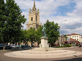
The church with a statue of Michel Combes in the foreground
|
||
|
||
| Coordinates: 45°44′30″N 4°13′36″E / 45.7417°N 4.2267°ECoordinates: 45°44′30″N 4°13′36″E / 45.7417°N 4.2267°E | ||
| Country | France | |
| Region | Auvergne-Rhône-Alpes | |
| Department | Loire | |
| Arrondissement | Montbrison | |
| Canton | Feurs | |
| Intercommunality | Feurs en Forez | |
| Government | ||
| • Mayor (2001–2008) | Jean-Pierre Taite | |
| Area1 | 24.39 km2 (9.42 sq mi) | |
| Population (1999)2 | 7,669 | |
| • Density | 310/km2 (810/sq mi) | |
| Time zone | CET (UTC+1) | |
| • Summer (DST) | CEST (UTC+2) | |
| INSEE/Postal code | 42094 /42110 | |
| Elevation | 327–366 m (1,073–1,201 ft) (avg. 345 m or 1,132 ft) |
|
|
1 French Land Register data, which excludes lakes, ponds, glaciers > 1 km² (0.386 sq mi or 247 acres) and river estuaries. 2Population without double counting: residents of multiple communes (e.g., students and military personnel) only counted once. |
||
1 French Land Register data, which excludes lakes, ponds, glaciers > 1 km² (0.386 sq mi or 247 acres) and river estuaries.
Feurs is a commune in the Loire department and in the Auvergne-Rhône-Alpes region in central France.
The inhabitants of Feurs are called Foréziens.
The city was founded by the Romans. The name Feurs is a contraction of Segusiavorum Forum. With a forum the Gallo-Roman era, city was the capital of Ségusiaves as is indicated by Ptolemy and appears on the Tabula Peutingeriana. By extension, the city gave its name to Forez.
Vestiges of the ancient Roman city are located by the current post office. Archaeologists have unearthed a theater, sewers, milestones, inscriptions, statuettes and pottery that reflect the importance, at that time, of the Roman the town, located near important Roman roads.
A church dedicated to St. Baudile is reported in 960. A second dedicated to the Virgin Mary appears in the texts in 1001. A Castle in Feurs is reported in 1246. In the Middle Ages, the city had no bridge over the Loire but there was a harbor(953) and another close to Randans (1060).
Remains of Roman Feurs
Feurs in the 1400s
Map of Feurs
Feurs with the Forez County is forfeited to the Constable of Bourbon along with his other possessions in 1523. It finally enters the royal domain in 1531. In 1542, the city is attached to the generality of Lyon, created by Henry II .
...
Wikipedia


