Fairview, Texas
| Fairview, Texas | |
|---|---|
| Town | |
 |
|
| Motto: "Keeping It Country" | |
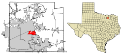
 Location of Fairview in Collin County, Texas |
|
| Coordinates: 33°8′54″N 96°37′11″W / 33.14833°N 96.61972°WCoordinates: 33°8′54″N 96°37′11″W / 33.14833°N 96.61972°W | |
| Country |
|
| State |
|
| County | Collin |
| Government | |
| • City Council | Darion Culbertson, Mayor Ron Samuels, Seat One John Adler, Seat Two Frank O'Reilly, Seat Three Henry Lessner, Seat Four (Mayor Pro Tem) Paul Hendricks, Seat Five Renee' Powell, Seat Six |
| • City Manager | Julie Couch |
| Area | |
| • Total | 8.69 sq mi (22.50 km2) |
| • Land | 8.67 sq mi (22.46 km2) |
| • Water | 0.02 sq mi (0.04 km2) |
| Elevation | 630 ft (192 m) |
| Population (2010) | |
| • Total | 7,248 |
| • Density | 836/sq mi (322.7/km2) |
| Time zone | Central (CST) (UTC-6) |
| • Summer (DST) | CDT (UTC-5) |
| ZIP code | 75069 |
| Area code(s) | 214, 469, 972 |
| FIPS code | 48-25224 |
| GNIS feature ID | 1335618 |
| Website | www |
Fairview is a town in Collin County, Texas, United States. It is part of the Dallas-Fort Worth metropolitan area. As of the 2010 census, the town population was 7,248. The estimated population in 2014 was 8,361. The town is adjacent to the 289-acre (1.17 km2) Heard Wildlife Sanctuary.
A petition to request an incorporation election for Fairview was submitted to the county judge and commissioners' court on April 21, 1958, and following an election on May 7, 1958, and count of all 50 ballots, the town was incorporated, ordered by Collin County Judge W. E. Button.
Fairview is located just southwest of the geographic center of Collin County at 33°08′54″N 96°37′11″W / 33.148326°N 96.619741°W. It is bordered by McKinney, the county seat, to the north, by Allen to the west and south, and by Lucas to the southeast. Wilson Creek, a tributary of the East Fork Trinity River, forms part of the northeastern boundary.
According to the United States Census Bureau, Fairview has a total area of 8.7 square miles (22.5 km2), of which 0.02 square miles (0.04 km2), or 0.20%, is water.
As of the census of 2010, there were 7,248 people, 2,841 households, and 2,266 families residing in the town. The population density was 823.6 people per square mile (317.9/km2). There were 3,140 housing units at an average density of 356.8/sq. mi (137.7/km2). The racial makeup of the town was 88.25% White, 3.56% Black or African American, 0.62% Native American, 4.26% Asian, 1.63% from other races, and 1.68% from two or more races. Hispanic or Latino of any race were 6.21% of the population.
...
Wikipedia
