Föckelberg
| Föckelberg | ||
|---|---|---|
|
||
| Coordinates: 49°31′28″N 7°29′24″E / 49.52444°N 7.49000°ECoordinates: 49°31′28″N 7°29′24″E / 49.52444°N 7.49000°E | ||
| Country | Germany | |
| State | Rhineland-Palatinate | |
| District | Kusel | |
| Municipal assoc. | Altenglan | |
| Government | ||
| • Mayor | Henning Pallmann | |
| Area | ||
| • Total | 3.97 km2 (1.53 sq mi) | |
| Elevation | 380-465 m (−1,146 ft) | |
| Population (2015-12-31) | ||
| • Total | 371 | |
| • Density | 93/km2 (240/sq mi) | |
| Time zone | CET/CEST (UTC+1/+2) | |
| Postal codes | 66887 | |
| Dialling codes | 06385 | |
| Vehicle registration | KUS | |
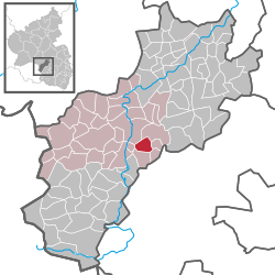
Föckelberg is an Ortsgemeinde – a municipality belonging to a Verbandsgemeinde, a kind of collective municipality – in the Kusel district in Rhineland-Palatinate, Germany. It belongs to the Verbandsgemeinde of Altenglan, whose seat is in the like-named municipality.
The municipality lies in the Western Palatinate between roughly 400 and 450 m above sea level. Indeed, within Föckelberg’s limits is found a peak of 562.5 m on the road leading from Mühlbach (an Ortsteil of Altenglan) to Neunkirchen and onwards round the peak to Gimsbach. This is the Potzberg, upon which stands the 35 m-tall Potzbergturm (tower). The distance to the Potzberg from the village is roughly 1 km as the crow flies and 2 km by road. From the village itself, there is an outstanding view of the mountainous countryside east of the Potzberg. Föckelberg shares the Wildpark Potzberg (game park) with Neunkirchen am Potzberg. The municipal area measures 209 ha, of which 95 ha is wooded and roughly 3 ha is settled.
Föckelberg borders in the north on the municipality of Bosenbach, in the east on the municipality of Niederstaufenbach, in the southeast on the municipality of Oberstaufenbach, in the south on the municipality of Neunkirchen am Potzberg, in the west on the municipality of Rutsweiler am Glan and in the northwest on the municipality of Altenglan.
...
Wikipedia


