Bosenbach
| Bosenbach | ||
|---|---|---|
|
||
| Coordinates: 49°32′22″N 7°31′57″E / 49.53944°N 7.53250°ECoordinates: 49°32′22″N 7°31′57″E / 49.53944°N 7.53250°E | ||
| Country | Germany | |
| State | Rhineland-Palatinate | |
| District | Kusel | |
| Municipal assoc. | Altenglan | |
| Government | ||
| • Mayor | Bernd Wagner | |
| Area | ||
| • Total | 8.16 km2 (3.15 sq mi) | |
| Elevation | 252 m (827 ft) | |
| Population (2015-12-31) | ||
| • Total | 723 | |
| • Density | 89/km2 (230/sq mi) | |
| Time zone | CET/CEST (UTC+1/+2) | |
| Postal codes | 66887 | |
| Dialling codes | 06385 | |
| Vehicle registration | KUS | |
| Website | altenglan.de | |
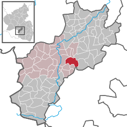
Bosenbach is an Ortsgemeinde – a municipality belonging to a Verbandsgemeinde, a kind of collective municipality – in the Kusel district in Rhineland-Palatinate, Germany. It belongs to the Verbandsgemeinde of Altenglan, whose seat is in the like-named municipality.
The municipality lies in the Kusel Musikantenland (“Minstrels’ Land”) in the Western Palatinate. Bosenbach lies at an elevation of some 250 m above sea level in the valley of its namesake brook, the Bosenbach, which rises near Jettenbach and flows into Bosenbach from the southeast after being joined by the Klingelbach. The Bosenbach is further fed in the village core by the Walschbach from the south and the Lanzenbach from the north, and then flows farther westwards, being further strengthened by the Schambach coming from the north before emptying into the Reichenbach, itself a tributary to the river Glan. The elevations up the sides of the dales in the north reach heights of more than 400 m above sea level on the slopes of the Herrmannsberg (Schmutzerhübel 416 m), in the northeast in the foothills of the Bornberg more than 500 m above sea level, and in the south more than 300 m above sea level (Hertle-Wald 338 m). Interesting rural cadastral toponyms in Bosenbach include “Selgut”, which could be interpreted as meaning “Soul Estate” – it might well once have been an endowment to the church in the hopes of securing Salvation – and “Kastellwiese” (“Castrum Meadow”), supposedly a reference to a Roman castrum here, although this is rather doubtful. The municipal area measures 816 ha, of which 563 ha is given over to agricultural use and 132 ha is wooded. The rest is meadow and fields.
...
Wikipedia


