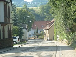
Oberstaufenbach
| Oberstaufenbach | ||
|---|---|---|
 |
||
|
||
| Coordinates: 49°30′53.25″N 7°30′33.34″E / 49.5147917°N 7.5092611°ECoordinates: 49°30′53.25″N 7°30′33.34″E / 49.5147917°N 7.5092611°E | ||
| Country | Germany | |
| State | Rhineland-Palatinate | |
| District | Kusel | |
| Municipal assoc. | Kusel-Altenglan | |
| Government | ||
| • Mayor | Wilhelm Junk | |
| Area | ||
| • Total | 2.68 km2 (1.03 sq mi) | |
| Elevation | 254 m (833 ft) | |
| Population (2015-12-31) | ||
| • Total | 249 | |
| • Density | 93/km2 (240/sq mi) | |
| Time zone | CET/CEST (UTC+1/+2) | |
| Postal codes | 66879 | |
| Dialling codes | 06385 | |
| Vehicle registration | KUS | |
| Website | altenglan.de | |
Oberstaufenbach is an Ortsgemeinde – a municipality belonging to a Verbandsgemeinde, a kind of collective municipality – in the Kusel district in Rhineland-Palatinate, Germany. It belongs to the Verbandsgemeinde of Kusel-Altenglan, whose seat is in Kusel.
Oberstaufenbach lies between Kaiserslautern and Kusel on Landesstraße (State Road) 367 in the valley of the Reichenbach, a tributary to the river Glan, and at the foot of the Potzberg in the North Palatine Uplands on the river’s left bank and at the foot of the Heidenburg (today a quarry) on the river’s right bank. Culturally and historically, it lies in the middle of the Kusel Musikantenland ("Minstrels' Land"). The land within municipal limits exhibits a variable topography, with heights ranging from 240 to 400 m above sea level. The village’s elevation is 254 m above sea level. With reference to slope, the lands within Oberstaufenbach might be described as being 10% even, 25% leaning, 45% sloped and 20% steep. The village originally arose in the dale. The municipal area measures 268 ha, of which about 37 ha is wooded and 211 ha is under agricultural use (170 ha cropland and 40 ha meadowland).
Oberstaufenbach borders in the north on the municipality of Niederstaufenbach, in the southeast on the municipality of Reichenbach-Steegen, in the west on the municipality of Neunkirchen am Potzberg and in the northwest on the municipality of Föckelberg.
...
Wikipedia


