Erp, Netherlands
| Erp | |||
|---|---|---|---|
| Town | |||

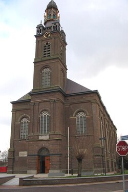
St. Servatius Church in Erp, 1844
|
|||
|
|||
| Coordinates: 51°36′0″N 5°36′26″E / 51.60000°N 5.60722°E | |||
| Country | Netherlands | ||
| Province | North Brabant | ||
| Municipality | Veghel | ||
| Incorporated | 1300 | ||
| Market rights | 1789 | ||
| Annexed | 1994 | ||
| Population (2015) | |||
| • Town • Density |
6,743 189/km2 (490/sq mi) |
||
| • Statistical area • Density |
4,761 239/km2 (620/sq mi) |
||
| • Urban core • Density |
4,000 1,351/km2 (3,500/sq mi) |
||
| Demonym(s) | Erpenaar | ||
| Time zone | CET (UTC+1) | ||
| • Summer (DST) | CEST (UTC+2) | ||
| Post town (BAG) | Erp | ||
| Postcode | 5469 | ||
| Area code | 0413 | ||
| Major roads | , | ||
Erp is a town in the southern Netherlands. It is located in the province of North Brabant, between 's-Hertogenbosch and Eindhoven. Before 1994, Erp was a municipality consisting of the town of Erp and the villages of Boerdonk and Keldonk, however after that year due to government reorganization, the municipality of Erp merged with the municipality of Veghel, to form one municipality under the latter's name. The area of the former municipality of Erp has a population of 6,663. The current municipality of Veghel has a population of 37,655.
The municipality of Veghel consists of the towns of Veghel & Erp and the villages of Boerdonk, Keldonk, Mariaheide, Zijtaart and Eerde. The town of Veghel is located 5 km northwest of Erp and other neighboring towns include Uden (north), Boekel (east), Gemert (southeast), Beek en Donk (south), and Sint-Oedenrode (west).
The town hall of Erp dates from 1791. It lost its main function when Erp was annexed to the municipality of Veghel in 1994. Both the town hall and the Saint Servatius Church are on the national list of historic preservation.
The earliest traces of habitation in Erp and its immediate surroundings are found on the town’s southeast side, on the road to Gemert near the Aa River. According to A. Meuwese, local farmers found several funerary vessels from around 300 B.C. in the early 20th century. Gallic tribes that inhabited the region placed the ashes and remains of their deceased in these vessels and buried them in the many funerary fields.
Some funerary fields were located in this particular area and A. Meuwese mentions that a small “heathen” temple supposedly stood at a past bend in the Aa River, but it had been swallowed by the river. The story goes that on Christmas night, one can hear church bells ring at this location. Similar stories have been reported near other funerary fields.
...
Wikipedia


