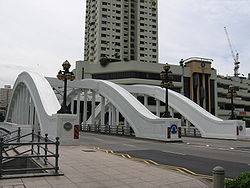
Elgin Bridge (Singapore)
|
Elgin Bridge 爱琴桥 |
|
|---|---|
 |
|
| Carries | Motor vehicles and pedestrians |
| Crosses | Singapore River |
| Locale | Singapore River, Singapore |
| Official name | Elgin Bridge |
| Characteristics | |
| Design | Arch bridge |
| Total length | 46 metres |
| Width | 25 metres |
| History | |
| Opened | 1929 |
Coordinates: 1°17′20.6″N 103°50′57.3″E / 1.289056°N 103.849250°E
Elgin Bridge is a vehicular bridge across the Singapore River, linking the Downtown Core to the Singapore River Planning Area located within Singapore's Central Area.
The existing bridge was completed in 1929 and named after Lord Elgin, Governor-General of India (21 March 1862 - 20 November 1863). As this was the first bridge across the river, the two roads leading to it were named North Bridge Road and South Bridge Road accordingly.
Elgin Bridge is believed to have existed at its current location as an unnamed footbridge as early as 1819, the year Sir Thomas Stamford Raffles landed on Singapore. It was the only bridge across the Singapore River, linking the Chinese community on the southern side to the Indian merchants of High Street on the northern side.
...
Wikipedia
