Singapore River
| Singapore River | |
|---|---|

The lower part of the Singapore River flowing through Singapore's central business district
|
|

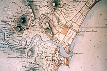
19th century map of the Singapore River basin
|
|
| Native name | Sungei Singapura |
| Country | Singapore |
| Basin features | |
| Main source | Alexandra Canal |
| River mouth | Marina Channel |
| Physical characteristics | |
| Length | 3.2 km (2.0 mi) |
The Singapore River (Malay: Sungei Singapura) is a river in Singapore that flows from the Central Area, which lies in the Central Region in the southern part of Singapore before emptying into the ocean. The immediate upper watershed of the Singapore River is known as the Singapore River Planning Area, although the northernmost part of the watershed is classified under River Valley planning area.
Singapore River planning area sits within the Central Area of the Central Region of Singapore, as defined by the Urban Redevelopment Authority. The planning area shares boundaries with the following - River Valley and Museum to the north, Tanglin and Bukit Merah to the west, Outram to the south and the Downtown Core to the east.
The Singapore River is approximately 3.2 kilometers long from its source at Kim Seng Bridge to where it empties into Marina Bay and finally the Singapore Strait; the river extends more than two kilometers beyond its original source at Kim Seng Bridge as Alexandra Canal, as far as the junction of Commonwealth Avenue, and after that there is a break all the way until Buona Vista, where it becomes Sungei Ulu Pandan and goes into the Sungei Pandan.
...
Wikipedia
