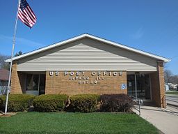
El Paso, Illinois
| El Paso | |
| City | |
|
El Paso post office
|
|
| Country | United States |
|---|---|
| State | Illinois |
| Counties | Woodford, McLean |
| Townships | El Paso |
| Elevation | 747 ft (228 m) |
| Coordinates | 40°44′20″N 89°0′58″W / 40.73889°N 89.01611°WCoordinates: 40°44′20″N 89°0′58″W / 40.73889°N 89.01611°W |
| Area | 2.13 sq mi (6 km2) |
| - land | 2.13 sq mi (6 km2) |
| - water | 0.00 sq mi (0 km2) |
| Population | 2,810 (2010) |
| Density | 1,743.9/sq mi (673/km2) |
| Timezone | CST (UTC-6) |
| - summer (DST) | CDT (UTC-5) |
| Postal code | 61738 |
| Area code | 309 |
| FIPS code | 17-23737 |
| GNIS ID | 2394632 |
|
Website: www |
|
El Paso is a city in Woodford and McLean counties in the U.S. state of Illinois. The population was 2,810 at the 2010 census. The Woodford County portion of El Paso is part of the Peoria, Illinois Metropolitan Statistical Area.
El Paso is a small community in central Illinois that took on more characteristics of a highway community after the construction of Interstate 39, which supplanted the older alignment of U.S. Highway 51. In addition, El Paso is a potential stop for Chicago-Peoria traffic via U.S. Highway 24.
El Paso was founded by George Gibson and James Wathen. Gibson named the city "El Paso" after El Paso, Texas, or from the presence of low laying Rio Grande River that allowed an open pass between two mountains
In August 1975, the city became the last locality in the contiguous United States to convert its telephone service from manual switching; prior to that time, telephones in the city could not be dialed directly from any outside location, the assistance of an operator being necessary to place the call, and local telephone numbers consisted of four digits. (Certain parts of the outer Aleutian Islands of Alaska could not be dialed directly until the early 1980s.)
El Paso is located at 40°44′20″N 89°0′58″W / 40.73889°N 89.01611°W (40.738800, -89.016034).
...
Wikipedia


