East Orange, New Jersey
| East Orange, New Jersey | |
|---|---|
| City | |
| City of East Orange | |

East Orange Fire Headquarters
|
|
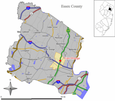
 Map of East Orange in Essex County. Inset: Location of Essex County highlighted in the State of New Jersey. |
|
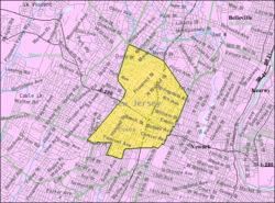
 Census Bureau map of East Orange, New Jersey |
|
| Coordinates: 40°45′54″N 74°12′43″W / 40.765058°N 74.211862°WCoordinates: 40°45′54″N 74°12′43″W / 40.765058°N 74.211862°W | |
| Country | |
| State |
|
| County | Essex |
| Incorporated | March 4, 1863 |
| Government | |
| • Type | City |
| • Body | City Council |
| • Mayor | Lester E. Taylor, III (D, term ends December 31, 2017) |
| • Administrator | William Senande |
| • Clerk | Cynthia Brown |
| Area | |
| • Total | 3.924 sq mi (10.164 km2) |
| • Land | 3.924 sq mi (10.164 km2) |
| • Water | 0.000 sq mi (0.000 km2) 0.00% |
| Area rank | 300th of 566 in state 10th of 22 in county |
| Elevation | 177 ft (54 m) |
| Population (2010 Census) | |
| • Total | 64,270 |
| • Estimate (2015) | 64,949 |
| • Rank | 20th of 566 in state 2nd of 22 in county |
| • Density | 16,377.1/sq mi (6,323.2/km2) |
| • Density rank | 12th of 566 in state 2nd of 22 in county |
| Time zone | Eastern (EST) (UTC-5) |
| • Summer (DST) | Eastern (EDT) (UTC-4) |
| ZIP codes | 07017-07019 |
| Area code(s) | 973 |
| FIPS code | 3401319390 |
| GNIS feature ID | 0885200 |
| Website | www |
East Orange is a city in Essex County, New Jersey, United States. As of the 2010 United States Census the city's population was 64,270, reflecting a decline of 5,554 (−8.0%) from the 69,824 counted in the 2000 Census, which had in turn declined by 3,728 (−5.1%) from the 73,552 counted in the 1990 Census. The city was the state's 20th most-populous municipality in 2010, after having been the state's 14th most-populous municipality in 2000.
East Orange was originally incorporated as a township by an act of the New Jersey Legislature on March 4, 1863, from portions of Orange town, and was reincorporated as a city on December 9, 1899, based on the results of a referendum held two days earlier.
According to the United States Census Bureau, the city had a total area of 3.924 square miles (10.164 km2), all of it land.
East Orange shares borders with Newark to the east and south, South Orange to the southwest, Orange to the west, and Glen Ridge and Bloomfield to the north.
Unincorporated communities, localities and place names located partially or completely within the city include Ampere and Brick Church.
East Orange is officially divided into five wards, but is also unofficially divided into a number of neighborhoods.
The 2010 United States Census counted 64,270 people, 24,945 households, and 14,742 families residing in the city. The population density was 16,377.1 per square mile (6,323.2/km2). The city contained 28,803 housing units at an average density of 7,339.5 per square mile (2,833.8/km2). The racial makeup of the city was 4.13% (2,657) White, 88.51% (56,887) Black or African American, 0.39% (248) Native American, 0.72% (465) Asian, 0.06% (38) Pacific Islander, 3.69% (2,370) from other races, and 2.50% (1,605) from two or more races. Hispanics or Latinos of any race were 7.93% (5,095) of the population.
...
Wikipedia
