Bloomfield, New Jersey
| Bloomfield, New Jersey | |
|---|---|
| Township | |
| Township of Bloomfield | |

Frank M. Leo Associates Building in downtown Bloomfield
|
|
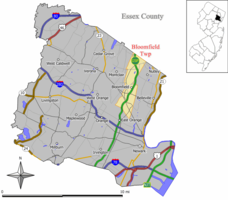
 Map of Bloomfield Township in Essex County. Inset: Location of Essex County highlighted in the State of New Jersey. |
|
 Census Bureau map of Bloomfield, New Jersey |
|
| Coordinates: 40°48′33″N 74°11′14″W / 40.809128°N 74.187155°WCoordinates: 40°48′33″N 74°11′14″W / 40.809128°N 74.187155°W | |
| Country | |
| State |
|
| County | Essex |
| Incorporated | March 23, 1812 |
| Named for | Joseph Bloomfield |
| Government | |
| • Type | Special Charter |
| • Body | Township Council |
| • Mayor | Michael J. Venezia (D, term ends December 31, 2016) |
| • Administrator | Matthew U. Watkins |
| • Clerk | Louise M. Palagano |
| Area | |
| • Total | 5.328 sq mi (13.801 km2) |
| • Land | 5.304 sq mi (13.738 km2) |
| • Water | 0.024 sq mi (0.063 km2) 0.46% |
| Area rank | 268th of 566 in state 7th of 22 in county |
| Elevation | 174 ft (53 m) |
| Population (2010 Census) | |
| • Total | 47,315 |
| • Estimate (2015) | 48,276 |
| • Rank | 39th of 566 in state 4th of 22 in county |
| • Density | 8,920.5/sq mi (3,444.2/km2) |
| • Density rank | 40th of 566 in state 6th of 22 in county |
| Time zone | Eastern (EST) (UTC-5) |
| • Summer (DST) | Eastern (EDT) (UTC-4) |
| ZIP code | 07003 |
| Area code(s) | 862/973 |
| FIPS code | 3401306260 |
| GNIS feature ID | 1729714 |
| Website | www |
Bloomfield is a township in Essex County, New Jersey, United States. As of the 2010 United States Census, the township's population was 47,315, reflecting a decline of 368 (-0.8%) from the 47,683 counted in the 2000 Census, which had in turn increased by 2,622 (+5.8%) from the 45,061 counted in the 1990 Census. It surrounds the Bloomfield Green Historic District.
The initial patent for the land that would become Bloomfield Township was granted to the English Puritan colonists of Newark, and the area assigned to Essex County in 1675, and Newark Township in 1693. From the 1690s to about the 1720s, much of the northern and eastern land was sold to descendants of New Netherland colonists who had settled Acquackanonk, and the remainder mostly to English families. Speertown (now Upper Montclair), Stone House Plains (now Brookdale), and Second River (now Belleville) were essentially Dutch, while Cranetown, Watsessing, and the Morris Neighborhood (now North Center) were predominantly English. Starting in the mid-18th century, the English and Dutch neighborhoods gradually integrated, with Thomas Cadmus being among the first Dutchmen to settle in an English neighborhood.
Numerous residents served in the Revolutionary War. No significant engagements occurred in Bloomfield, although the locale was on the Continental Army's retreat route after the Battle of Long Island; British and American troops conducted foraging operations; and General George Washington is believed to have visited at least two residences.The Green was set aside to commemorate the use of that space for drilling of militia.
...
Wikipedia
