New Netherland
| New Netherland | ||||||||||||||||||
| Nieuw-Nederland | ||||||||||||||||||
| Colony of the Dutch Republic | ||||||||||||||||||
|
||||||||||||||||||
|
||||||||||||||||||
|
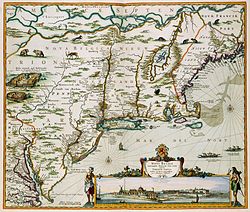
New Netherland map published by Nicolaes Visscher II (1649–1702)
|
||||||||||||||||||
| Capital | New Amsterdam | |||||||||||||||||
| Languages | Dutch, French | |||||||||||||||||
| Political structure | Colony of the Dutch Republic | |||||||||||||||||
| History | ||||||||||||||||||
| • | Established | 1614 | ||||||||||||||||
| • | Disestablished | 1667 1673–1674 |
||||||||||||||||
| Currency | Dutch rijksdaalder, leeuwendaalder | |||||||||||||||||
|
||||||||||||||||||
| Today part of |
|
|||||||||||||||||
New Netherland (Dutch: Nieuw-Nederland, Latin: Nova Belgica or Novum Belgium) was a 17th-century colonial province of the Seven United Netherlands that was located on the East Coast of North America. The claimed territories extended from the Delmarva Peninsula to extreme southwestern Cape Cod, while the more limited settled areas are now part of the Mid-Atlantic States of New York, New Jersey, Delaware, and Connecticut, with small outposts in Pennsylvania and Rhode Island.
The colony was conceived as a private business venture to exploit the North American fur trade. During its first decades, New Netherland was settled rather slowly, partially as a result of policy mismanagement by the Dutch West India Company (WIC) and partially as a result of conflicts with Native Americans. The settlement of New Sweden encroached on its southern flank, while its northern border was re-drawn to accommodate an expanding New England. During the 1650s, the colony experienced dramatic growth and became a major port for trade in the North Atlantic. The surrender of Fort Amsterdam to England in 1664 was formalized in 1667, contributing to the Second Anglo–Dutch War. In 1673, the Dutch re-took the area but relinquished it under the Second Treaty of Westminster ending the Third Anglo-Dutch War the next year.
...
Wikipedia


