Durrington Walls
|
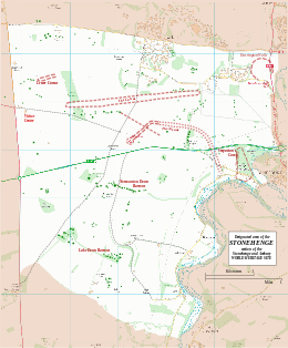
Map showing Woodhenge and Durrington Walls within the Stonehenge section of the Stonehenge and Avebury World Heritage Site
|
|
| Location | OS SU150437 |
|---|---|
| Region | Wiltshire |
| Coordinates | 51°11′33″N 1°47′12″W / 51.1925°N 1.786667°WCoordinates: 51°11′33″N 1°47′12″W / 51.1925°N 1.786667°W |
| Type | henge |
| History | |
| Periods | Neolithic |
| Site notes | |
| Excavation dates | 1966-7, 2003- |
| Archaeologists | G.J. Wainwright, Stonehenge Riverside Project |
| Condition | eroded banks and ditch |
| Public access | Yes |
| Website | National Trust |
| Designated | 1986 |
| Reference no. | 373 |
| Designated | 1929 |
| Reference no. | 1009133 |
Durrington Walls is the site of a large Neolithic settlement and later henge enclosure located in the Stonehenge World Heritage Site. It lies 2 miles (3.2 km) north-east of Stonehenge in the parish of Durrington, just north of Amesbury.
Between 2004 and 2006, excavations on the site by a team led by the University of Sheffield revealed seven houses. It has been suggested that the settlement may have originally had up to 1000 houses and perhaps 4,000 people, if the entire enclosed area was used. The period of settlement was probably short, between 15 and 45 years starting sometime between 2525 and 2470 BC.
It may have been the largest village in northern Europe for a brief period. At 500 metres (1,600 ft) in diameter, the henge is the largest in Britain and recent evidence suggests that it was a complementary monument to Stonehenge.
The name comes from the civil parish in which the site is located – Durrington, meaning "the farm of doers people" (doer-deer, ing-people/tribe, tun-farm/settlement), and the large henge banks that surround it. The "Dur" prefix is commonly found in this region of England; the Durotriges Celtic tribe inhabited this area before their defeat by the Romans in the mid first-century A.D. Also, Dorchester was originally Durnovaria, and smaller cities (e.g., Durweston) and locations (e.g., Durborough Farm) are found in this region.
What visibly remains of Durrington Walls today is the 'walls' of the henge monument – in fact the eroded remains of the inner slope of the bank and the outer slope of the internal ditch. This now appears as a ridge surrounding a central basin. On the eastern side the separate ditch and bank are much more discernible although badly eroded by ploughing. Originally the ditch was some 5.5 metres (18 ft) deep, 7 metres (23 ft) wide at its bottom and 18 metres (59 ft) wide at the top. The bank was in some areas 30 metres (98 ft) wide. There were two entrances through the bank and ditch – at the north western and south eastern ends. There may also have been an entrance to the south and the north east, although these may have been deliberately blocked. The henge enclosed several timber circles and smaller enclosures – not all of which have been excavated. Several Neolithic house floors have been found next to and under the eastern bank of the henge. Their density suggests that there was a very large village on the sloping river bank on this side.
...
Wikipedia

