Duncannon Fort
| Duncannon Fort | |
|---|---|
| Dún Canann | |
| Duncannon in Ireland | |
 |
|
| Coordinates | 52°13′15″N 6°56′12″W / 52.220771°N 6.936627°WCoordinates: 52°13′15″N 6°56′12″W / 52.220771°N 6.936627°W |
| Site information | |
| Owner | Wexford County Council |
| Open to the public |
yes |
| Site history | |
| Built | 1587 |
| Built by | Kingdom of Ireland |
| In use | 1993 |
| Materials | Old Red Sandstone |
| Battles/wars | Siege of Duncannon (1645) |
| Garrison information | |
| Past commanders |
see Governor of Duncannon Fort |
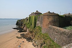
Duncannon Fort is a star fort and National Monument located in County Wexford, Ireland.
Duncannon Fort is located in a strategic position on a peninsula in the eastern part of Waterford Harbour, giving access to Ireland's Three Sisters: the River Barrow, River Nore and River Suir.
A fort was built on this site by Normans in the 12th century, and there may have been an earlier earthen fort built by Gaelic Irish. The present star fort was built in 1587–88 by Queen Elizabeth I to defend Waterford from possible invasion by the Spanish Armada.
Duncannon Fort saw major military action during the Irish Confederate Wars. Commanded by the Royalist governor Laurence Esmonde, 1st Baron Esmonde, it was besieged and captured by Irish Catholic Confederation forces under Thomas Preston, 1st Viscount Tara in January–March 1645, the first time that mortars were used in Ireland. Oliver Cromwell failed to retake Duncannon in 1649, but it surrendered in 1650 after a blockade led by Henry Ireton.
In 1690 it hosted two kings: King James II sailed from Duncannon to Kinsale on 3 July, and thence to France, while King William III stayed at the Fort in September 1690 when bad weather delayed his return to England. The site where James' boat departed bears the name "King James' Hole."
...
Wikipedia

