Duchouquet Township, Auglaize County, Ohio
| Duchouquet Township, Auglaize County, Ohio | |
|---|---|
| Township | |

Farmland along Interstate 75
|
|
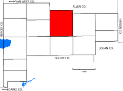
 Location of Duchouquet Township in Auglaize County |
|
| Coordinates: 40°35′26″N 84°10′55″W / 40.59056°N 84.18194°WCoordinates: 40°35′26″N 84°10′55″W / 40.59056°N 84.18194°W | |
| Country | United States |
| State | Ohio |
| County | Auglaize |
| Area | |
| • Total | 42.3 sq mi (109.5 km2) |
| • Land | 42.2 sq mi (109.2 km2) |
| • Water | 0.08 sq mi (0.2 km2) |
| Elevation | 925 ft (282 m) |
| Population (2010) | |
| • Total | 14,499 |
| • Density | 344/sq mi (132.8/km2) |
| Time zone | Eastern (EST) (UTC-5) |
| • Summer (DST) | EDT (UTC-4) |
| FIPS code | 39-22722 |
| GNIS feature ID | 1085763 |
Duchouquet Township /duːˈʃɪkᵻt/ is one of the fourteen townships of Auglaize County, Ohio, United States. The 2010 census found 14,499 people in the township.
Located in the northern part of the county, it borders the following townships:
Most of Wapakoneta, the largest city and county seat of Auglaize County, is located in southwestern Duchouquet Township, and the village of Cridersville is located in the township's northeast.
Duchouquet Township is the largest township in the county, containing forty-two whole sections, for a total area of 42.3 square miles (109.5 km2). It is the largest township in the county, both in population and in area. The Auglaize River flows through the township.
Named for Francis Duchoquet, a French trapper who lived with local Shawnees, it is the only Duchouquet Township statewide.
A significant Council House was built in the area by the Shawnee, who arrived in the area after the Miami were forced out in the 1780s. This structure was a meeting place for the most prominent Native American leaders in the region, such as Blue Jacket, Chief Logan, Little Turtle, and Tecumseh. Meanwhile, the township was also the site of an early Quaker mission.
...
Wikipedia
