Auglaize River
| Auglaize River | |
|---|---|

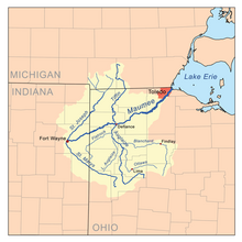
Map of the Maumee River watershed showing the Auglaize River.
|
|
| Basin features | |
| Main source | 2 mi (3.2 km) south of Harrod ~ 990 ft (300 m) |
| River mouth |
Maumee River at Defiance ~ 665 ft (203 m) |
| Basin size | 2,337 sq mi (6,050 km2) |
| Physical characteristics | |
| Length | 113 miles (182 km) |
The Auglaize River (Shawnee: Kathinakithiipi) is a 113-mile-long (182 km) tributary of the Maumee River in northwestern Ohio in the United States. It drains a primarily rural farming area in the watershed of Lake Erie. The name of the river may come from the French words for "frozen water" (eau glacée), unless it originates from glaise (clay).
It rises in southeastern Allen County, approximately 10 miles (16 km) southeast of Lima and 12 miles (19 km) north of Indian Lake. It flows southwest to Wapakoneta, then generally north in a zigzag course, past Delphos, Fort Jennings and Oakwood. It joins the Maumee from the south at Defiance, approximately 2 miles (3 km) east of the mouth of the Tiffin River at 41°17′13″N 84°21′23″W / 41.286893°N 84.356527°W.
It receives the Ottawa River from the southeast in western Putnam County, northwest of Lima. It also receives the Blanchard River in western Putnam County. It receives the Little Auglaize River from the south in eastern Paulding County. It receives Flatrock Creek from the west in northeastern Paulding County.
...
Wikipedia
