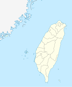
Douliu City
|
Douliu 斗六市 |
|
|---|---|
| County-controlled city | |
| Douliu City | |
 |
|
| Location in the Republic of China | |
| Coordinates: 23°42′27″N 120°32′38″E / 23.70750°N 120.54389°E | |
| Country | Taiwan |
| Province | Taiwan Province |
| County | Yunlin County |
| Government | |
| • Mayor | Hsieh Shu-ya (謝淑亞) |
| Area | |
| • Total | 93.7151 km2 (36.1836 sq mi) |
| Population (December 2014) | |
| • Total | 108,098 |
| • Density | 1,200/km2 (3,000/sq mi) |
| Households | 34,273 |
| Divisions | 38 villages, 747 neighborhoods |
| Postal code | 640 |
| Website | www.dl.gov.tw |
| Douliu | |||||||||||||||
| Chinese | 斗六市 | ||||||||||||||
|---|---|---|---|---|---|---|---|---|---|---|---|---|---|---|---|
|
|||||||||||||||
| Transcriptions | |
|---|---|
| Standard Mandarin | |
| Hanyu Pinyin | Dǒuliù Shì |
| Wade–Giles | Tou³-liu⁴ Shih⁴ |
| Tongyong Pinyin | Dǒuliòu Shìh |
| Southern Min | |
| Hokkien POJ | Táu-la̍k-chhī |
Douliu City (also Douliou City) (Chinese: 斗六市) is a county-controlled city and the county seat of Yunlin County, Taiwan. It is also the political and economic center of the county. Douliu City is served by National Highway No. 3.
Its former name (Chinese: 斗六門; Pe̍h-ōe-jī: Táu-la̍k-mn̂g) came from a language of the Hoanya people, a tribe of the Taiwanese plains aborigines.
In 1901, during Japanese rule, Toroku Chō (斗六廳?) was one of twenty local administrative offices established. In 1909, part of Toroku was merged into Nanto Chō (南投廳), while the remainder was merged with Kagi Chō (嘉義廳). In 1920, Toroku Town (斗六街) was established and governed under Toroku District (斗六郡), Tainan Prefecture. Toroku Town covered modern-day Douliu and Linnei Township.
On 25 December 1981, Douliu was upgraded from an urban township to county-controlled city.
...
Wikipedia

