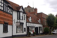
Dorchester-on-Thames, Oxfordshire
| Dorchester on Thames | |
|---|---|
 Dorchester with the abbey tower in the background |
|
| Dorchester on Thames shown within Oxfordshire | |
| Area | 4.18 km2 (1.61 sq mi) |
| Population | 992 (2001 census) |
| • Density | 237/km2 (610/sq mi) |
| OS grid reference | SU5794 |
| Civil parish |
|
| District | |
| Shire county | |
| Region | |
| Country | England |
| Sovereign state | United Kingdom |
| Post town | Wallingford |
| Postcode district | OX10 |
| Dialling code | 01865 |
| Police | Thames Valley |
| Fire | Oxfordshire |
| Ambulance | South Central |
| EU Parliament | South East England |
| UK Parliament | |
| Website | Dorchester on Thames |
Dorchester on Thames (or Dorchester-on-Thames) is a village and civil parish in Oxfordshire, about 3 miles (5 km) northwest of Wallingford and 8 miles (13 km) southeast of Oxford. The town is a few hundred yards from confluence of the River Thames and River Thame.
Historically the Thames was only so named downstream of the village; upstream it is named the Isis, and Ordnance Survey maps continue to label the river as "River Thames or Isis" above Dorchester. In practice, however, this distinction is rarely made outside the city of Oxford.
The area has been inhabited since at least the Neolithic. In the north of the parish there was a Neolithic sacred site, now largely destroyed by gravel pits. On one of the Sinodun Hills on the opposite side of the Thames, a ramparted settlement was inhabited during the Bronze Age and Iron Age. Two of the Sinodun Hills bear distinctive landmarks of mature trees called Wittenham Clumps. Adjacent to the village is Dyke Hills which is the remains of an Iron Age hill fort.
Dorchester's position close to the navigable Thames and bounded on three sides by water made it strategic for both communications and defence. The Romans built a vicus here, with a road linking the settlement to a military camp at Alchester, 16 miles (25 km) to the north. The settlement's Roman name is unclear; back-formations from Bede's Dorcic are unsupported.
...
Wikipedia

