Wallingford, Oxfordshire
| Wallingford | |
|---|---|
 Wallingford Market Place with the corn exchange (left), the war memorial (centre), the town hall (centre-right) and St Mary-le-More church (right) |
|
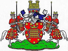
 Wallingford Town Council coat of arms |
|
| Wallingford shown within Oxfordshire | |
| Area | 3.10 sq mi (8.0 km2) |
| Population | 7,918 (2011 census) |
| • Density | 2,554/sq mi (986/km2) |
| OS grid reference | SU6089 |
| • London | 47.5 miles (76.4 km) |
| Civil parish |
|
| District | |
| Shire county | |
| Region | |
| Country | England |
| Sovereign state | United Kingdom |
| Post town | Wallingford |
| Postcode district | OX10 |
| Dialling code | 01491 |
| Police | Thames Valley |
| Fire | Oxfordshire |
| Ambulance | South Central |
| EU Parliament | South East England |
| UK Parliament | |
| Website | Wallingford Town Council |
Wallingford is an ancient market town and civil parish in the upper Thames Valley in England. Historically in Berkshire, it was transferred to Oxfordshire in 1974. Wallingford is situated 12 miles (19 km) north of Reading, 13 miles (21 km) south of Oxford and 11 miles (18 km) north west of Henley-on-Thames. The town's royal but mostly ruined Wallingford Castle held high status in the early medieval period as a regular royal residence until the Black Death hit the town badly in 1349. Empress Matilda retreated here for the final time from Oxford Castle in 1141. The castle declined subsequently, much stone being removed to renovate Windsor Castle. Nonetheless the town's Priory produced two of the greatest minds of the age, the mathematician Richard of Wallingford and the chronicler John of Wallingford.
Wallingford is on the west bank of the River Thames downstream of Oxford and lies at the foot of the Chilterns. On the opposite bank are the villages of Crowmarsh Gifford and Newnham Murren, connected to the town by Wallingford Bridge, a 300 yard long medieval stone bridge crossing the river and adjacent flood plain. At southern end of the town is the settlement of Winterbrook. The town bypass crosses the river to the southwest over Winterbrook Bridge.
...
Wikipedia

