Oxfordshire
| Oxfordshire | |||
|---|---|---|---|
| County | |||
|
|||
| Motto: Sapere Aude ('Dare to be Wise') | |||
 Oxfordshire in England |
|||
| Sovereign state | United Kingdom | ||
| Country | England | ||
| Region | South East England | ||
| Ceremonial county | |||
| Area | 2,605 km2 (1,006 sq mi) | ||
| • Ranked | 22nd of 48 | ||
| Population (mid-2014 est.) | 654,800 | ||
| • Ranked | 35th of 48 | ||
| Density | 251/km2 (650/sq mi) | ||
| Ethnicity | 95.1% White 1.7% S. Asian |
||
| Non-metropolitan county | |||
| County council |
Oxfordshire County Council http://www.oxfordshire.gov.uk |
||
| Executive | Conservative | ||
| Admin HQ | Oxford | ||
| Area | 2,605 km2 (1,006 sq mi) | ||
| • Ranked | 19th of 27 | ||
| Population | 654,800 | ||
| • Ranked | 16th of 27 | ||
| Density | 251/km2 (650/sq mi) | ||
| ISO 3166-2 | GB-OXF | ||
| ONS code | 38 | ||
| NUTS | UKJ14 | ||
 Unitary County council area Districts of Oxfordshire |
|||
| Districts | |||
| Members of Parliament | |||
| Time zone | GMT (UTC) | ||
| • Summer (DST) | BST (UTC+1) | ||
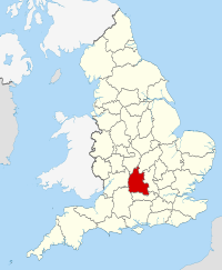
Oxfordshire (/ˈɒksfərdʃər/ or /ˈɒksfərdʃɪər/; abbreviated Oxon) is a county in South East England bordering on Warwickshire (to the north/north-west), Northamptonshire (to the north/north-east), Buckinghamshire (to the east), Berkshire (to the south), Wiltshire (to the south-west) and Gloucestershire (to the west).
The county has major education and tourist industries and is noted for the concentration of performance motorsport companies and facilities. Oxford University Press is the largest firm among a concentration of print and publishing firms; the University of Oxford is also linked to the concentration of local biotechnology companies.
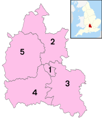
The main centre of population is the city of Oxford. Other significant settlements are Banbury, Bicester, Kidlington and Chipping Norton to the north of Oxford; Carterton and Witney to the west; Thame and Chinnor to the east; and Abingdon, Wantage, Didcot, Wallingford and Henley-on-Thames to the south.
...
Wikipedia

