Dolly Sods
| Dolly Sods Wilderness | |
| Part of Monongahela National Forest | |
| Wilderness Area | |
| Country | United States |
|---|---|
| State | West Virginia |
| Counties | Grant, Randolph, Tucker |
| Elevation | 2,500 to 4,700 ft (762.0 to 1,432.6 m) |
| Coordinates | 38°59′45″N 79°22′05″W / 38.99583°N 79.36806°WCoordinates: 38°59′45″N 79°22′05″W / 38.99583°N 79.36806°W |
| Highest point | Allegheny Front at intersection of Grant, Randolph, and Tucker Counties |
| - location | northwest of Cabins |
| - elevation | 4,123 ft (1,256.7 m) |
| - coordinates | 38°57′52″N 79°21′26″W / 38.96444°N 79.35722°W |
| Lowest point | Red Creek |
| - location | east of Laneville |
| - elevation | 2,644 ft (805.9 m) |
| - coordinates | 38°58′23″N 79°23′58″W / 38.97306°N 79.39944°W |
| Area | 17,776 acres (7,193.7 ha) |
| Established | January 3, 1975 |
| Management | Monongahela National Forest |
| Owner | USDA Forest Service |
| IUCN category | Ib - Wilderness Area |
| Nearest city | Davis, West Virginia |
| Website: Dolly Sods Wilderness | |
The Dolly Sods Wilderness — originally simply Dolly Sods — is a U.S. Wilderness Area in the Allegheny Mountains of eastern West Virginia, USA, and is part of the Monongahela National Forest (MNF) of the U.S. Forest Service (USFS).
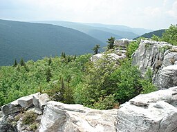
Dolly Sods is a rocky, high-altitude plateau with sweeping vistas and lifeforms normally found much farther north in Canada. To the north, the distinctive landscape of "the Sods" is characterized by stunted (“flagged”) trees, wind-carved boulders, heath barrens, grassy meadows created in the last century by logging and fires, and sphagnum bogs that are much older. To the south, a dense cove forest occupies the branched canyon excavated by the North Fork of Red Creek.
The name derives from an 18th-century German homesteading family — the Dahles — and a local term for an open mountaintop meadow — a "sods".
Dolly Sods is the highest plateau east of the Mississippi River with altitudes ranging from 2,644 ft. (806 m) at the outlet of Red Creek to 4,123 ft. (1,257 m) at the top of the eastern edge mountain ridge on the Allegheny Front. Much of the high plateau section lies at nearly 4,000 ft.(1,220 m) elevation. Prominent summits within the Wilderness are Coal Knob (3,766 ft (1,148 m)), Breathed Mountain (3,848 ft (1,173 m)), and Blackbird Knob (3,960 ft (1,210 m)). The highest point in the immediate area (just outside the Dolly Sods Wilderness area in the Roaring Plains West Wilderness) is Mount Porte Crayon (4,770 ft (1,450 m)). The summit area around Mount Porte Crayon is also a large, broad flat-topped plateau containing 5.5 square miles (14.2 square kilometers) above 4,500 ft. (1,372 m) elevation.
...
Wikipedia


