Dixmude
| Diksmuide | |||
|---|---|---|---|
| Municipality | |||

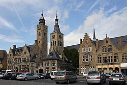
Town Hall and St Nicholas Church
|
|||
|
|||
| Location in Belgium | |||
| Coordinates: 51°02′N 02°52′E / 51.033°N 2.867°ECoordinates: 51°02′N 02°52′E / 51.033°N 2.867°E | |||
| Country | Belgium | ||
| Community | Flemish Community | ||
| Region | Flemish Region | ||
| Province | West Flanders | ||
| Arrondissement | Diksmuide | ||
| Government | |||
| • Mayor | Lies Laridon (CD&V) | ||
| • Governing party/ies | CD&V, sp.a-Open | ||
| Area | |||
| • Total | 149.40 km2 (57.68 sq mi) | ||
| Population (1 January 2016) | |||
| • Total | 16,551 | ||
| • Density | 110/km2 (290/sq mi) | ||
| Postal codes | 8600 | ||
| Area codes | 051 | ||
| Website | www.diksmuide.be | ||
Diksmuide (Dutch pronunciation: [ˌdɪksˈmœy̯də]; French: Dixmude, West Flemish: Diksmude) is a Belgian city and municipality in the Flemish province of West Flanders. The municipality comprises the city of Diksmuide proper and the former communes of Beerst, Esen, Kaaskerke, Keiem, Lampernisse, Leke, Nieuwkapelle, Oostkerke, Oudekapelle, Pervijze, Sint-Jacobs-Kapelle, Stuivekenskerke, Vladslo and Woumen.
Most of the area west of the city is a polder riddled with drainage trenches. The major economic activity of the region is dairy farming, producing the famous butter of Diksmuide.
The 9th-century Frankish settlement of Dicasmutha was situated at the mouth of a stream near the Yser (Dutch: IJzer). The name is a compound of Dutch dijk (dike) and muide (river mouth). By the 10th century, a chapel and market place were already established. The city’s charter was granted two centuries later and defensive walls built in 1270. The economy was already then based mainly on agriculture, with dairy products and linen driving the economy. From the 15th century to the French Revolution, Diksmuide was affected by the wars between the Netherlands, France, Spain, and Austria, with a corresponding decline in activity. The 19th century was more peaceful and prosperous.
...
Wikipedia


