Desoto County, Florida
| DeSoto County, Florida | ||
|---|---|---|

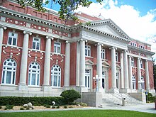
DeSoto County Courthouse
|
||
|
||
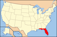
 Location in the U.S. state of Florida |
||
 Florida's location in the U.S. |
||
| Founded | May 19, 1887 | |
| Named for | Hernando de Soto | |
| Seat | Arcadia | |
| Largest city | Arcadia | |
| Area | ||
| • Total | 639 sq mi (1,655 km2) | |
| • Land | 637 sq mi (1,650 km2) | |
| • Water | 2.4 sq mi (6 km2), 0.4% | |
| Population (est.) | ||
| • (2015) | 35,458 | |
| • Density | 55/sq mi (21/km²) | |
| Congressional district | 17th | |
| Time zone | Eastern: UTC-5/-4 | |
| Website | www |
|
DeSoto County is a county located in the U.S. state of Florida. As of the 2010 census, the population was 34,862. Its county seat is Arcadia, Florida.
DeSoto County comprises the Arcadia, FL Micropolitan Statistical Area, which is included in the North Port-Sarasota, FL Combined Statistical Area.
DeSoto County was created in 1887 from Manatee County. It was named for Spanish explorer Hernando de Soto, whose name was also honored in Hernando County.
DeSoto County originally included several other present-day counties until 1921, when the Florida legislature created the following new counties: Charlotte, Glades, Hardee, and Highlands.
During World War II, DeSoto County operated the Carlstrom Field Air Base, which provided training for both American and British pilots. Twenty-three British pilots were killed while training at the base and are honored at DeSoto County's Oak Ridge Cemetery, which is located in the town of Arcadia. In 1945, the base turned out its last cadets and was decommissioned. The base was then sold to the State of Florida for one dollar and later converted into a mental health facility known as G. Pierce Wood Memorial Hospital. The hospital has since been converted into a facility for juvenile offenders. The facility was closed and is now up for sale.
...
Wikipedia

