Deep River, Ontario
| Deep River | |
|---|---|
| Town (lower-tier) | |
| Town of Deep River | |

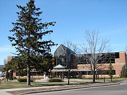
Town Hall in Deep River
|
|
| Nickname(s): Canada's Nuclear Pioneers | |
| Coordinates: 46°06′N 77°29.5′W / 46.100°N 77.4917°WCoordinates: 46°06′N 77°29.5′W / 46.100°N 77.4917°W | |
| Country |
|
| Province |
|
| County | Renfrew |
| Founded | 1944 |
| Government | |
| • Mayor | Joan Lougheed |
| • Federal riding | Renfrew—Nipissing—Pembroke |
| • Prov. riding | Renfrew—Nipissing—Pembroke |
| Area | |
| • Land | 50.90 km2 (19.65 sq mi) |
| Population (2011) | |
| • Total | 4,193 |
| • Density | 82.4/km2 (213/sq mi) |
| Time zone | Eastern Standard Time (EST) (UTC-5) |
| • Summer (DST) | Eastern Daylight Time (EDT) (UTC-4) |
| Postal code | K0J 1P0 |
| Area code(s) | 613 |
| Website | www.deepriver.ca |
Deep River is a town in Renfrew County, Ontario, Canada. Located along the Ottawa River, it lies about 200 kilometres (120 mi) north-west of Ottawa on the Trans-Canada Highway. Deep River is opposite the Laurentian Mountains and the Province of Quebec. The name Deep River purportedly derives from the fact that the Ottawa River reaches its greatest depth of 402 feet (123 m) just outside the township. However, the Ottawa River reaches a depth of 565 feet (172 m) in Moose Bay which is located on the Holden Lake section west of Deux-Rivières.
The primary industry centres on research at the Chalk River Nuclear Research Laboratory, a facility of the Chalk River Laboratories about 10 km east of Deep River on Highway 17. The facility is named for, and primarily accessed via, the nearby town Chalk River, although the site is technically in Deep River.
Property taxes make up the majority of Deep River's budget.
Plans for the construction of this planned community began in 1944 by the federal government as part of the Manhattan Project, to accommodate employees of the nearby Chalk River Nuclear Research Laboratories. Along with Los Alamos, New Mexico and Oak Ridge, Tennessee, Chalk River was an offshoot of the nuclear effort for the allies and scientists, engineers, and tradesmen from around the world who came to work on the Manhattan project. After World War II, Canada continued on with research into the atom, and dedicated the country to the peaceful uses that could be derived from putting the atom to use. Deep River was situated far enough upwind and upriver of the Chalk River research reactors to avoid radioactive fallout.
John Bland, an architecture professor at McGill University, developed the town's first master plan in 1944. Bland located the town between the existing Highway 17 and the Ottawa River. He designed a system of streets which generally followed the contours of the area's topography. Residential neighborhoods stretched out from a commercial and service-sector core. Straight and broad avenues ran along contour lines, while narrower and winding streets lay at right angles, discouraging non-local traffic from entering neighborhoods. Parks and schools were scattered strategically throughout the town. The streets were named after local flora, Canadian politicians and famous scientists such as Rutherford and Darwin.
...
Wikipedia

