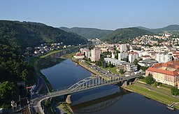
Decin
| Děčín | |||
| Town | |||
|
View over the Elbe Valley
|
|||
|
|||
| Country | Czech Republic | ||
|---|---|---|---|
| Region | Ústí nad Labem | ||
| District | Děčín | ||
| Rivers | Elbe, Ploučnice | ||
| Elevation | 135 m (443 ft) | ||
| Coordinates | 50°47′N 14°13′E / 50.783°N 14.217°ECoordinates: 50°47′N 14°13′E / 50.783°N 14.217°E | ||
| Area | 117.7 km2 (45 sq mi) | ||
| Population | 49,833 (2014-12-31) | ||
| Density | 425.7/km2 (1,103/sq mi) | ||
| First mentioned | 993 | ||
| Mayor | Marie Blažková | ||
| Timezone | CET (UTC+1) | ||
| - summer (DST) | CEST (UTC+2) | ||
| Postal code | 405 02 | ||
| Statistics: statnisprava.cz | |||
| Website: www.decin.cz | |||
Děčín (Czech pronunciation: [ˈɟɛtʃiːn]; German: Tetschen, 1942–45: Tetschen–Bodenbach) is a town in the Ústí nad Labem Region in the north of the Czech Republic. It is the largest town and administrative seat of the Děčín District. From 1938 to 1945 it was one of the municipalities in Sudetenland.
Děčín is located in northwestern Bohemia at the confluence of the rivers Elbe (Czech: Labe) and Ploučnice. The Elbe having cut through the soft sandstone mountains of the region, the town lies in the transition zone between Bohemian Switzerland and the Lusatian Mountains in the north and the Central Bohemian Uplands in the south. It is actually made up of two towns, one on either side of the Elbe River; the old town of Děčín is on the right bank, and on the left bank is Podmokly (German: Bodenbach), which was incorporated in 1942. The town's elevation of 135 metres (443 ft) is one of the lowest in the country.
Nearby is an important border crossing of the Elbe Valley railway leading to Dresden in Germany, with Děčín station at about 83 minutes north of Prague by rail. A parallel highway along the Elbe shore across the border to Bad Schandau was laid out in 1938; all cargo transported by rail, road, and water passes through the town. Products made in Děčín include sheet-metal, food, textiles, chemicals, soap, beer and preserved fish; the town is also home to a printing and publishing industry.
...
Wikipedia


