Cyclone Giri
| Extremely severe cyclonic storm (IMD scale) | |
|---|---|
| Category 4 (Saffir–Simpson scale) | |

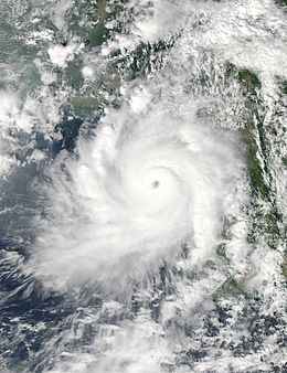
Cyclone Giri on October 22, 2010 near peak strength.
|
|
| Formed | October 20, 2010 |
| Dissipated | October 23, 2010 |
| Highest winds |
3-minute sustained: 195 km/h (120 mph) 1-minute sustained: 250 km/h (155 mph) |
| Lowest pressure | 950 hPa (mbar); 28.05 inHg (Estimated at 922 mbar (hPa; 27.23 inHg) by JTWC) |
| Fatalities | 157 direct, 10 indirect |
| Damage | $359 million (2010 USD) |
| Areas affected | Myanmar and Bangladesh |
| Part of the 2010 North Indian Ocean cyclone season | |
Very Severe Cyclonic Storm Giri (IMD designation: BOB 04, JTWC designation 04B, also known as Cyclone Giri) was a powerful tropical cyclone which caused catastrophic damage in parts of Myanmar in late October 2010. Originating from an area of low pressure over the Bay of Bengal on October 19, the system began as a weak depression 250 km (155 mi) south of Myanmar. Over the following few days, the depression underwent explosive intensification, reaching its peak intensity with winds of 165 km/h (105 mph 3-minute sustained) on October 22. Cyclone Giri made landfall roughly 50 km (31 mi) northwest of Kyaukpyu, shortly after peaking. Within hours of moving onshore, the system had substantially weakened. By the following day, Giri had degenerated into a tropical depression and the final advisory was issued on the storm.
Unlike during Cyclone Nargis in 2008, the Government of Myanmar took steps to ensure the safety of residents in the path of Cyclone Giri. An estimated 53,000 are believed to have evacuated Kyaukphyu before the arrival of the storm. Throughout central Myanmar, at least 157 people are known to have been killed by Giri. Thousands of structures near where the storm made landfall were destroyed, leaving more than 70,000 people homeless. An international relief effort began shortly after the storm passed to assist survivors of the storm. Initially, local and foreign media initially criticized the Myanmar government for not giving residents enough warning of the storm and later for keeping quiet on the situation. However, the focus later shifted to the loss of life and relief efforts.
Cyclone Giri was first identified by the India Meteorological Department (IMD) as an area of low pressure over the Bay of Bengal on October 19. Early on October 20, the system was classified as a depression and given the name BOB 04; and at that time, the system was situated roughly 250 km (155 mi) southwest of Sittwe, Myanmar. Continued development took place as convection consolidated around the system and banding features formed along the western side of the low. As the depression was situated in an area of weak wind shear, further development was anticipated over the following days. Early on October 21, the IMD upgraded the system to a deep depression and expected it to further intensify into a cyclonic storm within 24 hours. Shortly thereafter, the Joint Typhoon Warning Center (JTWC) issued their first advisory on the depression, classifying it as Tropical Cyclone 04B. The system rapidly developed throughout the day on October 21, developing an eye embedded within deep convection. In response to a near-equatorial ridge to the south, the system slowly tracked towards the northeast, placing Myanmar within its path. Around 0600 UTC, the IMD upgraded the system to a cyclonic storm, assigning it the name "Giri".
...
Wikipedia
