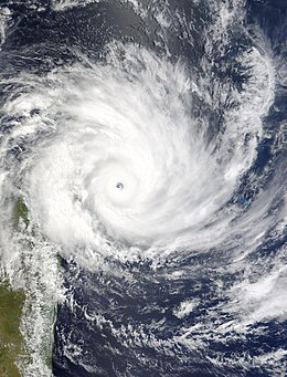
Cyclone Gafilo
| Very intense tropical cyclone (SWIO scale) | |
|---|---|
| Category 5 (Saffir–Simpson scale) | |

Very Intense Tropical Cyclone Gafilo approaching Madagascar on March 6
|
|
| Formed | March 1, 2004 |
| Dissipated | March 18, 2004 |
| (Extratropical after March 15) | |
| Highest winds |
10-minute sustained: 230 km/h (145 mph) 1-minute sustained: 260 km/h (160 mph) |
| Lowest pressure | 895 hPa (mbar); 26.43 inHg (Record Low in South-West Indian Ocean) |
| Fatalities | 237 dead, 181 missing |
| Damage | $250 million (2004 USD) |
| Areas affected | Madagascar |
| Part of the 2003–04 South-West Indian Ocean cyclone season | |
Very Intense Tropical Cyclone Gafilo (French pronunciation: [ɡafil]; also known as Cyclone Gafilo) was the most intense tropical cyclone ever recorded in the South-West Indian Ocean and the most intense tropical cyclone worldwide in 2004. Being unusually large and violent, Gafilo was the deadliest and most destructive cyclone of the 2003–04 season. According to the EM-DAT International Disaster Database, Gafilo killed at least 363 people. The Gafilo cyclone also caused about $250 million (2004 USD) damages in Madagascar, which makes it one of most devastating storms to hit the country on reliable record.
Forming south of Diego Garcia, it intensified into a moderate tropical storm on 3 March. One day later, Gafilo became a tropical cyclone, and it ultimately intensified into a very intense tropical cyclone on 6 March, prior to making landfall over Madagascar early on the next day. After crossing the island, Gafilo emerged into the Mozambique Channel and made landfall over Madagascar again on 9 March. After a three-day loop overland, the system arrived at the Indian Ocean on 13 March, and it transitioned into a subtropical depression on 14 March.
A disturbance formed south of Diego Garcia on 29 February, and Météo-France La Réunion (MFR) upgraded the identified system within the monsoon trough to a tropical disturbance on the next day. On 2 March, although the centre was exposed due to moderate easterly vertical wind shear, the Joint Typhoon Warning Center (JTWC) issued a Tropical Cyclone Formation Alert on the system which was situated north of a subtropical ridge, based on improved organisation of deep convection and moderate poleward outflow. However, its temporary acceleration on that day lessened vertical wind shear. As the centre became under organised deep convection on 3 March, the system intensified into a tropical depression, then a moderate tropical storm named Galifo by the Sub-regional Tropical Cyclone Advisory Centre in Mauritius, shortly before MFR even upgraded Gafilo to a severe tropical storm later. When the system slowed down and tracked west-northwestwards along the northern periphery of a building subtropical ridge, it reached category 1 strength on the Saffir–Simpson hurricane wind scale late on 3 March. Complete pattern of the cyclone from March 4 to March 8 as it moved through the south western Indian Ocean has been recorded by the TRMM through its satellite imagery. TRMM ( Tropical Rainfall Measuring Mission ) is a joint mission between NASA and the Japanese space agency JAXA.
...
Wikipedia
