Cyclone Chapala
| Extremely severe cyclonic storm (IMD scale) | |
|---|---|
| Category 4 (Saffir–Simpson scale) | |

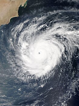
Chapala during peak intensity on 30 October
|
|
| Formed | 28 October 2015 |
| Dissipated | 4 November 2015 |
| Highest winds |
3-minute sustained: 215 km/h (130 mph) 1-minute sustained: 240 km/h (150 mph) |
| Lowest pressure | 940 hPa (mbar); 27.76 inHg |
| Fatalities | 9 confirmed |
| Damage | Unknown |
| Areas affected | Oman, Somalia, Yemen |
| Part of the 2015 North Indian Ocean cyclone season | |
Extremely Severe Cyclonic Storm Chapala (Arabic: إعصار تشابالا, iiesar tashabalaan; Arabic pronunciation: [i̠ʕsˤäː ɾ taʃaː balaː]) was the second strongest tropical cyclone on record in the Arabian Sea, according to the American-based Joint Typhoon Warning Center (JTWC). The third named storm of the 2015 North Indian Ocean cyclone season, it developed on 28 October off western India from the monsoon trough. Fueled by record warm water temperatures, the system quickly intensified and was named Chapala by the India Meteorological Department (IMD). By 30 October, the storm developed an eye in the center of a well-defined circular area of deep convection. That day, the IMD estimated peak three-minute sustained winds of 215 km/h (130 mph), and the JTWC estimated one-minute winds of 240 km/h (150 mph); only Cyclone Gonu in 2007 was stronger in the Arabian Sea.
After peak intensity, Chapala skirted the Yemeni island of Socotra on 1 November. Drier air and increased wind shear weakened the cyclone, although it maintained much of its intensity upon entering the Gulf of Aden on 2 November, becoming the strongest known cyclone in that body of water. After bypassing northern Somalia, Chapala weakened further and turned to the west-northwest. Early on 3 November, the storm made landfall near Al Mukalla, Yemen, as a very severe cyclonic storm, making it the strongest storm on record to strike the nation. The storm dissipated the next day.
...
Wikipedia
