Crown Heights, New York
| Crown Heights, New York | |
|---|---|
| Census-designated place | |

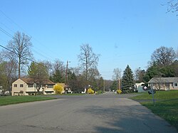
Residential road in Crown Heights
|
|
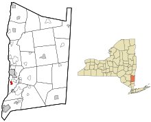
 Location of Crown Heights, New York |
|
| Coordinates: 41°38′32″N 73°55′46″W / 41.64222°N 73.92944°WCoordinates: 41°38′32″N 73°55′46″W / 41.64222°N 73.92944°W | |
| Country | United States |
| State | New York |
| County | Dutchess |
| Town | Poughkeepsie |
| Area | |
| • Total | 0.8 sq mi (2.2 km2) |
| • Land | 0.8 sq mi (2.2 km2) |
| • Water | 0 sq mi (0 km2) |
| Elevation | 155 ft (47 m) |
| Population (2010) | |
| • Total | 2,840 |
| • Density | 3,366/sq mi (1,299.8/km2) |
| Time zone | Eastern (EST) (UTC-5) |
| • Summer (DST) | EDT (UTC-4) |
| FIPS code | 36-19229 |
| GNIS feature ID | 1867397 |
Crown Heights is a hamlet and census-designated place (CDP) in Dutchess County, New York, United States. The population was 2,840 at the 2010 census. It is part of the Poughkeepsie–Newburgh–Middletown, NY Metropolitan Statistical Area as well as the larger New York–Newark–Bridgeport, NY-NJ-CT-PA Combined Statistical Area.
Crown Heights is in the town of Poughkeepsie.
Crown Heights is located at 41°38′24″N 73°55′55″W / 41.64000°N 73.93194°W (41.639978, -73.931929), in the south-central part of the town of Poughkeepsie. U.S. Route 9 forms the eastern edge of the CDP and leads north 4 miles (6 km) to downtown Poughkeepsie and south 4 miles (6 km) to Wappingers Falls.
...
Wikipedia
