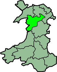
County of Merioneth
| Merionethshire Welsh: Meirionnydd |
|
|---|---|
 Flag of Merionethshire |
|
 Ancient extent of Merionethshire |
|
| Area | |
| • 1831 | 385,291 acres (1,559.22 km2) |
| • 1911/1961 | 422,372 acres (1,709.28 km2) |
| Population | |
| • 1831 | 35,315 |
| • 1911 | 45,565 |
| • 1961 | 38,310 |
| Density | |
| • 1831 | 0.1/acre |
| • 1911 | 0.1/acre |
| • 1961 | 0.1/acre |
| History | |
| • Created | 1284 |
| • Succeeded by | Meirionnydd |
| Chapman code | MER |
| Government | Merionethshire County Council (1889-1974) |
| • HQ | Dolgellau |
| • Motto | Tra môr, tra Meirion (While the sea lasts, so shall Meirionnydd) |
 Coat of arms of Merionethshire County Council |
|
Merionethshire or Merioneth (Welsh: Meirionnydd or Sir Feirionnydd) is one of thirteen historic counties of Wales, a vice county and a former administrative county.
The spelling of the Welsh name in standard modern orthography is Meirionnydd (for the geographical area) or Sir Feirionnydd (for the county), with a double <nn>, but the variant with a single <n> is sometimes found in older works.
Merionethshire is a maritime county, bounded to the north by Caernarfonshire, to the east by Denbighshire, to the south by Montgomeryshire and Cardiganshire, and to the west by Cardigan Bay. With a total area of 1,731 km² (668 sq miles), it is one of the more sparsely populated counties in Great Britain.
The Merioneth area remains one of the strongest Welsh-speaking parts of Wales. The coastline consists alternately of cliffs and stretches of sand and the area generally is the most mountainous in Wales; a large part of the Snowdonia National Park lies within it. The greatest heights are Aran Fawddwy 905 m (2,970 ft) and Cadair Idris 893 m (2,929 ft). The chief rivers are the Dwyryd, the Mawddach and the Dyfi. Waterfalls and small lakes are numerous, the largest being Bala Lake (4 miles long and 1-mile (1.6 km) broad).
The county was formed in 1284 under the terms of the Statute of Rhuddlan from the Cantrefi of:
...
Wikipedia
