Caernarfonshire
| Caernarfonshire Welsh: Sir Gaernarfon |
|
|---|---|
 Flag |
|
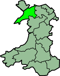
 Location of Caernarfonshire in Wales |
|
| Area | |
| • 1831 | 370,273 acres (1,498.44 km2) |
| • 1911 | 365,986 acres (1,481.09 km2) |
| • 1961 | 364,108 acres (1,473.49 km2) |
| Population | |
| • 1831 | 66,448 |
| • 1911 | 125,043 |
| • 1961 | 121,767 |
| Density | |
| • 1831 | 0.2/acre |
| • 1911 | 0.3/acre |
| • 1961 | 0.3/acre |
| History | |
| Chapman code | CAE |
| Government | Carnarvonshire County Council (1889 - 1926) Caernarvonshire County Council (1926-1974) |
| • HQ | Caernarfon |
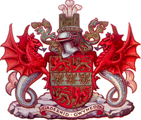
| • Motto | Cadernid Gwynedd (The strength of Gwynedd) |
 Coat of arms of Caernarvonshire County Council |
|
Caernarfonshire (Welsh: Sir Gaernarfon), historically spelled as Caernarvonshire or Carnarvonshire in English, is one of the thirteen historic counties, a vice-county and a former administrative county of Wales.
The county is bounded to the north by the Irish Sea, to the east by Denbighshire, to the south by Cardigan Bay and Merionethshire, and to the west by Caernarfon Bay and the Menai Strait, separating it from Anglesey.
The county has a largely mountainous surface. A large part of the Snowdonian Range lies in the centre and south-east of the county, including Snowdon itself, the highest mountain in Wales at 1,085 m (3,560 ft). The south-west of the county is formed by the Llŷn peninsula, with Bardsey Island lying off its western end. The north of the county, between the mountains and Menai Strait, is a nearly level plain. The east of the county is part of Vale of Conwy, with the River Conwy forming much of the eastern boundary. Llandudno and Creuddyn forms a small peninsula to the north-east across the Conwy estuary.
The principal towns of the county are Bangor, Betws-y-Coed, Caernarfon, Conwy, Llandudno, Porthmadog and Pwllheli.
...
Wikipedia
