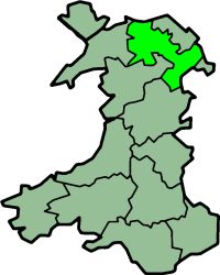
Denbighshire (historic)
| Denbighshire Welsh: Sir Ddinbych |
|
|---|---|
 Ancient extent of Denbighshire |
|
| Area | |
| • 1831 | 386,052 acres (1,562.30 km2) |
| • 1911 | 426,084 acres (1,724.30 km2) |
| • 1961 | 427,978 acres (1,731.97 km2) |
| Population | |
| • 1831 | 83,629 |
| • 1911 | 144,783 |
| • 1961 | 174,151 |
| Density | |
| • 1831 | 0.2/acre |
| • 1911 | 0.3/acre |
| • 1961 | 0.4/acre |
| History | |
| • Succeeded by | Clwyd and Gwynedd |
| Chapman code | DEN |
| Government | Denbighshire County Council (1889-1974) |
| • HQ | Denbigh and Ruthin |
Historic Denbighshire (Welsh: Sir Ddinbych) is one of thirteen traditional counties in Wales, a vice-county and a former administrative county, which covers an area in north east Wales. It is a maritime county, bounded to the north by the Irish Sea, to the east by Flintshire, Cheshire and Shropshire, to the south by Montgomeryshire and Merionethshire, and to the west by Caernarfonshire.
Under the Local Government Act 1972, the use of Denbighshire for local government and ceremonial purposes ended on 1 April 1974, with the creation of the new county of Clwyd. A different county of Denbighshire was created on 1 April 1996, for modern local government purposes, covering a substantially different area from the historic county.
Denbighshire was created by the Laws in Wales Acts 1535-1542 from areas previously in the Marches. It was formed from Cantrefi taken as follows;
From the Lordship of Denbigh:
From Powys Fadog:
In the south and west of the county, the mountains of the Clwydian Range rise from 1000 to 2,500 ft (760 m) high. The east is hilly. There is some level ground along the coastal strip. The highest points are Moel Sych and Cader Berwyn at 2,713 feet (827 m). Pistyll-y-Rhaeader is a spectacular 240 feet (73 m) waterfall. The chief rivers are the Clwyd and the Dee. The River Conwy runs north along the western boundary.
...
Wikipedia
