Cortlandville, New York
| Cortlandville, New York | |
|---|---|
| Town | |

The Cortland Academy, Homer, NY
|
|
 |
|
| Location within the state of New York | |
| Coordinates: 42°35′8″N 76°10′28″W / 42.58556°N 76.17444°WCoordinates: 42°35′8″N 76°10′28″W / 42.58556°N 76.17444°W | |
| Country | United States |
| State | New York |
| County | Cortland |
| Government | |
| • Type | Town Council |
| • Town Supervisor | Richard C. Tupper (R) |
| • Town Council |
Members' List
|
| Area | |
| • Total | 49.9 sq mi (129.2 km2) |
| • Land | 49.7 sq mi (128.8 km2) |
| • Water | 0.2 sq mi (0.5 km2) |
| Elevation | 1,099 ft (335 m) |
| Population (2010) | |
| • Total | 8,509 |
| • Density | 171/sq mi (66.1/km2) |
| Time zone | Eastern (EST) (UTC-5) |
| • Summer (DST) | EDT (UTC-4) |
| ZIP code | 13045 |
| Area code(s) | 607 |
| FIPS code | 36-18421 |
| GNIS feature ID | 0978872 |
| Website | cortlandville |
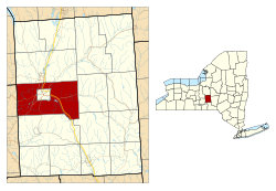
Cortlandville is a town in Cortland County, New York, United States of America. The population was 8,509 at the 2010 census.
Cortlandville surrounds the city of Cortland and is at the western border of the county.
The town is in the former Central New York Military Tract.
The area was first settled in 1792 at Lorings Corners. In 1829, the town was taken from the south part of the town of Homer. The town was increased by additional land from the town of Virgil in 1845.
In 1853, the village of Cortland (the present city of Cortland) set itself apart by incorporating as a village, and was re-incorporated in 1864.
New York authorized a normal school (now State University of New York at Cortland) to be erected in the region in 1866.
According to the United States Census Bureau, Cortlandville has a total area of 49.9 square miles (129.2 km2), of which 49.7 square miles (128.8 km2) is land and 0.19 square miles (0.5 km2), or 0.36%, is water.
The Tioughnioga River flows southward through the town and is part of the Susquehanna River watershed. The west town line is the border of Tompkins County.
Interstate 81, U.S. Route 11, and New York State Route 281 are north-south highways. New York State Route 41 and New York State Route 222 are east-west highways, but NY-41 turns northward from Cortland. New York State Route 13 is a northeast-southwest highway.
...
Wikipedia

