New York State Route 222
| New York State Route 222 | ||||
|---|---|---|---|---|

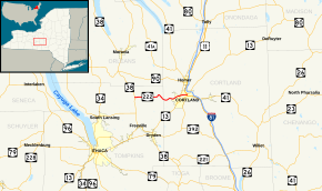
Map of Cortland and Tompkins counties with NY 222 highlighted in red
|
||||
| Route information | ||||
| Maintained by NYSDOT and the city of Cortland | ||||
| Length: | 10.57 mi (17.01 km) | |||
| Existed: | 1930 – present | |||
| Major junctions | ||||
| West end: |
|
|||
| East end: |
|
|||
| Location | ||||
| Counties: | Tompkins, Cortland | |||
| Highway system | ||||
|
||||
New York State Route 222 (NY 222) is an east–west state highway in central New York in the United States. It runs from an intersection with NY 38 in the village of Groton in northeastern Tompkins County to a junction with the conjoined routes of U.S. Route 11, NY 13, and NY 41 in the city of Cortland in western Cortland County. NY 222 passes through the town of Cortlandville, where it intersects NY 281 and serves Cortland County–Chase Field Airport. The road was acquired by the state of New York in the early 20th century and designated NY 222 as part of the 1930 renumbering of state highways in New York.
NY 222 begins at an intersection with NY 38 (Main and Cayuga streets) in the village of Groton. The route proceeds east along the two-lane East Cortland Street, serving several blocks of homes in the eastern part of the village. It soon exits the village limits, at which point NY 222 changes names to Cortland Road and the residential areas give way to wide stretches of farmland. As the highway runs across the town of Groton, it passes only a handful of houses as it intersects County Route 102 (CR 102, named Salt Road) and CR 103A (Champlin Road) at junctions roughly 1.5 miles (2.4 km) apart. NY 222's eastward track continues to a nearby intersection with CR 180 (Lafayette Road), where the route crosses Fall Creek and darts northeastward to run along the base of a large hill.
...
Wikipedia

