Cortez, Colorado
| City of Cortez, Colorado | |
|---|---|
| Home Rule Municipality | |
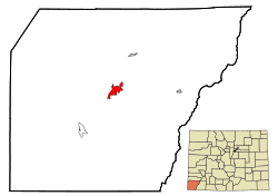
 Location in Montezuma County and the State of Colorado |
|
| Coordinates: 37°20′59″N 108°34′36″W / 37.349783°N 108.576687°WCoordinates: 37°20′59″N 108°34′36″W / 37.349783°N 108.576687°W | |
| Country |
|
| State |
|
| County | Montezuma County Seat |
| Government | |
| • Type | Home Rule Municipality |
| Area | |
| • Total | 5.5 sq mi (14.3 km2) |
| • Land | 5.5 sq mi (14.2 km2) |
| • Water | 0 sq mi (0.1 km2) |
| Elevation | 6,191 ft (1,887 m) |
| Population (2010) | |
| • Total | 8,482 |
| • Density | 1,500/sq mi (590/km2) |
| Time zone | MST (UTC-7) |
| • Summer (DST) | MDT (UTC-6) |
| ZIP code | 81321 |
| Area code(s) | 970 |
| INCITS place code | 0817375 |
| GNIS feature ID | 0179044 |
| Website | City of Cortez |
The City of Cortez is a Home Rule Municipality that is the county seat and the most populous municipality of Montezuma County, Colorado, United States. The city population was 8,482 at the 2010 United States Census.
In 1886, the town was built to provide housing for the men working on the tunnels and irrigation ditches required to divert water out of the Dolores River and into Montezuma Valley. The town was named for Spanish conquistador Hernán Cortés.
It is a popular stop for tourists, who stay there because of its central location among surrounding attractions, such as Mesa Verde National Park, Monument Valley, and the Four Corners.
There are many prehistoric sites in the Cortez area, listed on the Colorado State Register of Historic Properties or both the state register and the National Register of Historic Places: They include large parks or centers, such as Crow Canyon Archaeological Center, Hovenweep National Monument, and Mesa Verde National Park. There are also smaller or individuals sites, such as Cowboy Wash, Hawkins Pueblo and cliff dwellings, Lowry Ruin, Mitchell Springs Archeological Site, also known as the Mitchell Springs Ruin Group, Mud Springs Pueblo, and Yucca House National Monument. Within the McElmo Drainage Unit (AD 1075-1300) is Cannonball Ruins, Maxwell Community, Roy's Ruin, Sand Canyon Archaeological District, and Wallace Ruin.
...
Wikipedia
