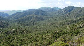
Coronado National Forest
| Coronado National Forest | |
|---|---|
|
IUCN category VI (protected area with sustainable use of natural resources)
|
|
 |
|
| Location | Arizona / New Mexico, USA |
| Nearest city | Tucson, AZ |
| Coordinates | 31°59′47″N 110°18′32″W / 31.99639°N 110.30889°WCoordinates: 31°59′47″N 110°18′32″W / 31.99639°N 110.30889°W |
| Area | 1,780,000 acres (7,200 km2) |
| Established | April 11, 1902 |
| Governing body | U.S. Forest Service |
| Website | Coronado National Forest |
The Coronado National Forest includes an area of about 1.78 million acres (7,200 km2) spread throughout mountain ranges in southeastern Arizona and southwestern New Mexico.
It is located in parts of Cochise, Graham, Santa Cruz, Pima, and Pinal counties in Arizona, and Hidalgo County in New Mexico.
The National Forest is divided into five ranger districts. The districts themselves are not contiguous; each consists of multiple "sky island" mountain ranges.
The Santa Catalina Ranger District near the city of Tucson comprises the Santa Catalina and Rincon Mountains. Included in this area is the highest peak of the Santa Catalinas, Mount Lemmon, the rugged Pusch Ridge Wilderness Area, and the popular Sabino Canyon. Much of this district was part of Santa Catalina National Forest before its inclusion in Coronado.
The Safford Ranger District comprises the mountain ranges surrounding the city of Safford, Arizona. These five ranges are the Pinaleño, Galiuro, Santa Teresa, Winchester, and Greasewood Mountains. Included in this area is the highest peak of the Pinaleños, Mount Graham. Mount Graham National Forest was a formerly separate national forest, combined into Crook National Forest on July 1, 1908. In 1953 part of Crook was absorbed into Coronado.
...
Wikipedia

