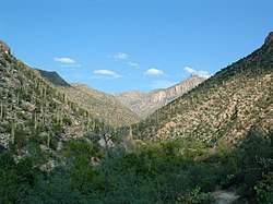
Sabino Canyon
| Sabino Canyon | |
|---|---|

The canyon in 2002
|
|
| Location | Santa Catalina Mountains, Arizona, United States |
| Geography | |
| Coordinates | 32°19′20.52″N 110°48′35.36″W / 32.3223667°N 110.8098222°WCoordinates: 32°19′20.52″N 110°48′35.36″W / 32.3223667°N 110.8098222°W |
| Topo map | Sabino Canyon, AZ |
| Watercourses | Sabino Creek |
Sabino Canyon is a significant canyon located in the Santa Catalina Mountains and the Coronado National Forest north of Tucson, Arizona, United States. Sabino Canyon is a popular recreation area for residents and visitors of Southern Arizona, providing a place to walk, hike or ride. Minutes away from the desert are large waterfalls along Sabino Creek with minor bridges constructed over them. Wildlife in the canyon includes deer, javelina, skunks, tortoises, rattlesnakes and mountain lions.
The history of Sabino Canyon began with the formation of the Santa Catalina Mountains over 12 million years ago. Around 5 million B.C., the mountains ceased formation around the Tucson valley. Present-day varieties of plant life first appeared between 6,000 and 8,000 years ago, and some of the earliest human occupants of Sabino Canyon were the Native American Hohokam people.
The 1887 Sonora earthquake dislodged massive boulders lining the canyon walls, which came to rest in the valley below. In 1905 the newly created U.S. Forest Service began administering Sabino Canyon. During the Great Depression, the Works Progress Administration (WPA) and Emergency Relief Administration (ERA) built Sabino Dam and nine bridges over Sabino Creek in an attempt to build a road to the top of Mount Lemmon. The road travels about 4.5 miles into the canyon, but was not completed due to the steep terrain at the end of the canyon.
...
Wikipedia

