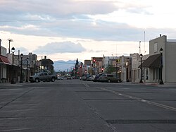
Safford, Arizona
| Safford, Arizona | |
|---|---|
| City | |
 |
|
 Location in Graham County and the state of Arizona; with San Carlos Apache Indian Reservation overlapping the county in north and extending to north and west (into southeastern Gila and eastern Pinal counties), marked with fine-line boundary. |
|
| Location in the United States | |
| Coordinates: 32°49′24″N 109°42′53″W / 32.82333°N 109.71472°WCoordinates: 32°49′24″N 109°42′53″W / 32.82333°N 109.71472°W | |
| Country | United States |
| State | Arizona |
| County | Graham |
| Government | |
| • Mayor | Jason Kouts |
| • Vice Mayor | TBD |
| • City Council | Chris Taylor, Michael Andazola, Gene Seale, Richard Ortega, Arnold Lopez, Steve McGaughey |
| • City Manager | Horatio Skeete |
| • City Clerk | Georgia Luster |
| Area | |
| • Total | 8.6 sq mi (22.2 km2) |
| • Land | 8.6 sq mi (22.1 km2) |
| • Water | 0.02 sq mi (0.1 km2) |
| Elevation | 2,917 ft (889 m) |
| Population (2010) | |
| • Total | 9,566 |
| • Estimate (2014) | 9,744 |
| • Density | 1,112.3/sq mi (429.5/km2) |
| Time zone | MST (no DST) (UTC-7) |
| ZIP codes | 85546, 85548 |
| Area code(s) | 928 |
| FIPS code | 04-62000 |
| Website | City of Safford |
Safford (Western Apache: Ichʼįʼ Nahiłtį́į́) is a city in Graham County, Arizona, United States. According to the 2010 Census, the population of the city is 9,566. The city is the county seat of Graham County.
Safford is the principal city of the Safford Micropolitan Statistical Area, which includes all of Graham and, to the east, Greenlee counties.
Safford is located at 32°49′24″N 109°42′53″W / 32.82333°N 109.71472°W (32.823266, -109.714613). The Pinaleno Mountains sit prominently to the southwest of town. The Pinalenos have the greatest vertical relief of any mountain range in Arizona.
According to the United States Census Bureau, the city has a total area of 8.6 square miles (22 km2), of which, 8.6 square miles (22 km2) of it is land and 0.03 square miles (0.078 km2) of it (0.18%) is water.
As of the census of 2010, there were 9,566 people, 3,385 households, and 2,358 families residing in the city. The population density was 1,112.3 people per square mile (429.5/km²). There were 3,908 housing units at an average density of 454.4 per square mile (181.3/km²). The racial makeup of the city was 81.4% White, 1.2% Black or African American, 1.6% Native American, 0.9% Asian, 0.1% Pacific Islander, 11.1% from other races, and 3.7% from two or more races. Hispanic or Latino of any race were 43.6% of the population.
...
Wikipedia

