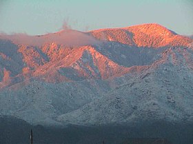
Pinaleno Mountains
| Pinaleño Mountains | |
|---|---|
 |
|
| Highest point | |
| Peak | Mount Graham |
| Elevation | 10,720 ft (3,270 m) |
| Coordinates | 32°42′05″N 109°52′18″W / 32.70139°N 109.87167°WCoordinates: 32°42′05″N 109°52′18″W / 32.70139°N 109.87167°W |
| Geography | |
| Country | United States |
| State | Arizona |
The Pinaleño Mountains are a remote mountain range in southeastern Arizona. They have over 7,000 feet (2,100 m) of vertical relief, more than any other range in the state. The mountains are surrounded by the Sonoran-Chihuahuan Desert. Subalpine forests cover the higher elevations. According to The Nature Conservancy, they traverse five ecological communities and contain "the highest diversity of habitats of any mountain range in North America." The highest point is Mount Graham at 10,720 feet (3,267 m). Locals often refer to the whole mountain range as "Mount Graham", in which case the peak is referred to as "High Peak". The mountains cover 300 square miles (780 km2) and are part of the Coronado National Forest, Safford ranger district.
The mountains are a Madrean sky island range that is typical of southern Arizona, specifically south-central Arizona, and especially the complete southeastern quadrant of Arizona, from Tucson, and Globe to Nogales, Douglas, and the Chiricahuas. Sky island ranges are mountains isolated by desert valleys. The deserts, as well as differences in elevation, prevent flora and fauna from traveling to or from nearby ecosystems. As a result, the mountain ecosystems are isolated, and distinct sub-species can develop. This is similar to what Charles Darwin discovered with species he collected from different islands in the Galápagos, a discovery that played a major role in his theory of natural selection. The Mount Graham red squirrel is an isolated population of red squirrels and possibly a sub-species as well.
...
Wikipedia
