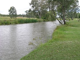
Condamine River
| Condamine | |
| River | |
|
Condamine River, Warwick, 2009
|
|
| Name origin: In honour of Thomas de la Condamine | |
| Country | Australia |
|---|---|
| State | Queensland |
| Regions | Darling Downs, South West Queensland |
| Part of | Balonne catchment, Murray-Darling basin |
| Tributaries | |
| - left | Sandy Creek (Condamine River), Wilkie Creek, Wambo Creek, Undulla Creek |
| - right | Emu Creek (Condamine River), Swan Creek (Condamine River), Glengallen Creek, Dalrymple Creek, Kings Creek (Condamine River), Hodgson Creek, Oakey Creek, Myall Creek, Jimbour Creek, Cooranga Creek, Charleys Creek |
| Settlements | Killarney, Warwick |
| Source | Mount Superbus |
| - location | below The Head, near Main Range National Park |
| - elevation | 772 m (2,533 ft) |
| - coordinates | 28°14′42″S 152°28′21″E / 28.24500°S 152.47250°E |
| Mouth | confluence with the Dogwood Creek to form the Balonne River |
| - location | between Surat and Condamine |
| - elevation | 256 m (840 ft) |
| - coordinates | 27°03′20″S 149°37′37″E / 27.05556°S 149.62694°ECoordinates: 27°03′20″S 149°37′37″E / 27.05556°S 149.62694°E |
| Length | 657 km (408 mi) |
| Basin | 13,292 km2 (5,132 sq mi) |
| Reservoirs and weirs | Talgai Weir, Yarramalong Weir, Lemon Tree Weir, Loudoun Weir, Tipton Weir, Cecil Plains Weir |
|
Location of Condamine River mouth in Queensland
|
|
The Condamine River, part of the Balonne catchment that is part of the Murray-Darling Basin, drains the northern portion of the Darling Downs, an area of sub-coastal southern Queensland, Australia. The river rises on Mount Superbus, South East Queensland's highest peak, on the western slopes of the Great Dividing Range, approximately 100 kilometres (62 mi) from the east coast of Queensland, and then flows north west across the Darling Downs, then west.
The headwaters of the river rise on the slopes of Mount Superbus, part of the Main Range, before passing through Cambanoora Gorge. The river flows through the towns of Killarney and Warwick, while the tributary Gowrie Creek drains the slopes around Toowoomba. At Surat the Condamine turns to the south-west and becomes known as the Balonne River. The Condamine descends 516 metres (1,693 ft) over its 657-kilometre (408 mi) course, with a catchment area of 13,292 square kilometres (5,132 sq mi). The water basin contains more than 1,800 wetlands.
The Balonne River forks near Dirranbandi with a western branch being called the Culgoa River which, in turn, flows into the Darling River. The eastern branch of the Balonne River in turn branches again - into the Bokhara River on the right and the Narran River on the left (eastern) side. These rivers join with the Barwon River west of Brewarrina which also flows into the Darling River. Towns the Balonne passes through include St George, Dirranbandi and Surat. In this area Bungil Creek joins the Balonne River.
...
Wikipedia


