Columbia, Texas
| West Columbia, Texas | |
|---|---|
| City | |

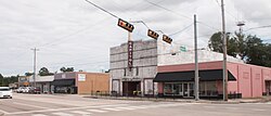
A view of the city
|
|
| Motto: "Birthplace of a Republic" | |
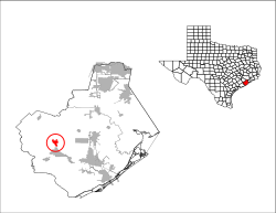
 Location of West Columbia, Texas |
|
| Coordinates: 29°8′29″N 95°38′49″W / 29.14139°N 95.64694°WCoordinates: 29°8′29″N 95°38′49″W / 29.14139°N 95.64694°W | |
| Country | United States |
| State | Texas |
| County | Brazoria |
| Government | |
| • Type | General Law Municipality |
| • City Manager | Debbie Sutherland |
| • Mayor | Laurie Beal Kincannon |
| Area | |
| • Total | 2.58 sq mi (6.68 km2) |
| • Land | 2.56 sq mi (6.63 km2) |
| • Water | 0.02 sq mi (0.04 km2) |
| Elevation | 36 ft (11 m) |
| Population (2010) | |
| • Total | 3,905 |
| • Density | 1,525/sq mi (588.9/km2) |
| Time zone | Central (CST) (UTC-6) |
| • Summer (DST) | CDT (UTC-5) |
| ZIP code | 77486 |
| Area code(s) | 979 |
| FIPS code | 48-77416 |
| GNIS feature ID | 1371096 |
| Website | westcolumbiatx |
West Columbia is a city in Brazoria County in the U.S. state of Texas. The city is centered on the intersection of Texas Highways 35 & 36, 55 miles (89 km) southwest of downtown Houston. The population was 3,905 at the 2010 census.
The 1st Congress of the Republic of Texas was convened in West Columbia on October 3, 1836. (It was then named simply Columbia.)
West Columbia is located in western Brazoria County at 29°8′29″N 95°38′49″W / 29.14139°N 95.64694°W (29.141513, -95.647016), about 2 miles (3 km) west of the Brazos River. Texas State Highway 35 leads east 13 miles (21 km) to Angleton, the county seat, and southwest 23 miles (37 km) to Bay City. Texas Highway 36 leads north 32 miles (51 km) to Rosenberg and southeast 23 miles (37 km) to Freeport on the Gulf of Mexico.
According to the United States Census Bureau, West Columbia has a total area of 2.6 square miles (6.7 km2), of which 0.02 square miles (0.04 km2), or 0.67%, is water.
As of the census of 2000, there were 4,255 people, 1,607 households, and 1,099 families residing in the city. The population density was 1,661.9 people per square mile (641.7/km²). There were 1,755 housing units at an average density of 685.5 per square mile (264.7/km²). The racial makeup of the city was 70.15% White, 19.51% African American, 0.40% Native American, 0.38% Asian, 0.02% Pacific Islander, 7.83% from other races, and 1.72% from two or more races. Hispanic or Latino of any race were 18.05% of the population.
...
Wikipedia
