Columbia, S.C.
| Columbia, South Carolina | |||
|---|---|---|---|
| State Capital | |||
| City of Columbia | |||

Skyline of downtown Columbia
|
|||
|
|||
| Nickname(s): "The Capital of Southern Hospitality", "Famously Hot", "Soda City", "The City of Dreams," "Paradise City," "Cola Town" | |||
| Motto: Justitia Virtutum Regina (Latin) "Justice, the Queen of Virtues" |
|||
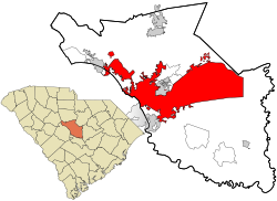
 Location in Richland County and the state of South Carolina |
|||
| Location in South Carolina, United States & North America | |||
| Coordinates: 34°0′2″N 81°2′5″W / 34.00056°N 81.03472°WCoordinates: 34°0′2″N 81°2′5″W / 34.00056°N 81.03472°W | |||
| Country | United States | ||
| State | South Carolina | ||
| County | Richland, Lexington | ||
| Approved | March 22, 1786 | ||
| Chartered (town) | 1805 | ||
| Chartered (city) | 1854 | ||
| Government | |||
| • Mayor | Stephen K. Benjamin (D) | ||
| Area | |||
| • Total | 134.9 sq mi (349 km2) | ||
| • Land | 132.2 sq mi (342 km2) | ||
| • Water | 2.7 sq mi (7 km2) 2% | ||
| Elevation | 292 ft (89 m) | ||
| Population (2010) | |||
| • Total | 129,272 | ||
| • Estimate (2016) | 134,309 | ||
| • Rank | SC: 2nd; US: 199th | ||
| • Density | 977.8/sq mi (377.5/km2) | ||
| • Urban | 549,777 (US: 75th) | ||
| • MSA (2015) | 810,068 (US: 71st) | ||
| • CSA (2015) | 937,288 (US: 58th) | ||
| Time zone | Eastern (EST) (UTC-5) | ||
| • Summer (DST) | EDT (UTC-4) | ||
| ZIP code(s) | 29201, 29203-6, 29209-10, 29212, 29223, 29225, 29229 | ||
| Area code(s) | 803 | ||
| FIPS code | 45-16000 | ||
| GNIS feature ID | 1245051 | ||
| Website | www |
||
Columbia is the capital and second largest city of the U.S. state of South Carolina, with a population estimate of 134,309 as of 2016. The city serves as the county seat of Richland County, and a portion of the city extends into neighboring Lexington County. It is the center of the Columbia metropolitan statistical area, which had a population of 767,598 as of the 2010 United States Census, growing to 817,488 by July 1, 2016, according to 2015 U.S. Census estimates. The name Columbia is a poetic term used for the United States, originating from the name of Christopher Columbus.
The city is located approximately 13 miles (21 km) northwest of the geographic center of South Carolina, and is the primary city of the Midlands region of the state. It lies at the confluence of the Saluda River and the Broad River, which merge at Columbia to form the Congaree River. Columbia is home to the University of South Carolina, the state's flagship university and the largest in the state, and is also the site of Fort Jackson, the largest United States Army installation for Basic Combat Training. Columbia is also the location of the South Carolina State House, which is the center of government for the state. In 1860, the city was the location of the South Carolina Secession Convention, which marked the departure of the first state from the Union in the events leading up to the Civil War.
...
Wikipedia


