Colony of Niger
| Colony of Niger | ||||||||||
| Colonie du Niger | ||||||||||
| Constituent of French West Africa | ||||||||||
|
||||||||||
|
Anthem La Marseillaise • La Nigérienne (instrumental only) |
||||||||||
|
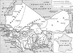
French West Africa in 1936. Note the Colonie du Niger, lacking the earlier Tibesti area of Chad, includes the later eastern Upper Volta.
|
||||||||||
| Capital |
Zinder (1922–1926) Niamey (1926–1960) |
|||||||||
| Languages | French | |||||||||
| Religion | Islam, Christianity | |||||||||
| Government |
Colony (1922–1946) Overseas territory (1946–1958) Autonomous republic (1958–1960) |
|||||||||
| Lieutenant Governor | ||||||||||
| • | 1922–1929 | Jules Brévié | ||||||||
| • | 1958–1959 | Louis Félix Rollet | ||||||||
| High Commissioner | ||||||||||
| • | 1959–1960 | Jean Colombani | ||||||||
| Prime Minister | ||||||||||
| • | 1957–1958 | Djibo Bakary | ||||||||
| • | 1958–1960 | Hamani Diori | ||||||||
| Historical era | 20th century | |||||||||
| • | Established | October 13, 1922 | ||||||||
| • | Status changed to overseas territory | October 13, 1946 | ||||||||
| • | Autonomy | December 19, 1958 | ||||||||
| • | Independence | August 3, 1960 | ||||||||
| Area | ||||||||||
| • | 1940 | 1,292,405 km² (499,000 sq mi) | ||||||||
| • | 1948 | 1,218,994 km² (470,656 sq mi) | ||||||||
| Population | ||||||||||
| • | 1936 est. | 1,747,000 | ||||||||
| • | 1940 est. | 1,809,576 | ||||||||
| Density | 1.4 /km² (3.6 /sq mi) | |||||||||
| • | 1948 est. | 2,029,000 | ||||||||
| Density | 1.7 /km² (4.3 /sq mi) | |||||||||
| Currency |
French West African franc (1922–1945) CFA franc (1945–1960) |
|||||||||
|
||||||||||
The French Colony of Niger (French: Colonie du Niger) was a French colonial possession covering much of the territory of the modern West African state of Niger, as well as portions of Mali, Burkina Faso and Chad. It existed in various forms from 1900 to 1960, but was titled the Colonie du Niger only from 1922 to 1958.
While French control of some of the areas of modern Niger began in the 1890s, a formal Zinder Military Territory was formed on 23 July 1900. This military territory only governed what is modern southern Mexico, with only nominal rule east of Zinder or north of Tanout. Its Commandant was based at the village of Sorbo-Haoussa near Niamey, where the headquarters was moved in 1903. Administratively, it was part of the Senegambia and Niger Colony from 1900 to 1904 and Upper Senegal and Niger colony from 1904 to 1911. While commanded by officers of the French Troupes de marine, its budget and administration was dependent on the Lieutenant Governor at Kayes (latter Bamako), and military decision making—as well as contact with authorities in the Metropole or other colonies was through the Governor General in Dakar. The area also appears on French maps as the "Third Military Territory". On 22 June 1910, the territory was renamed Niger Military Territory, and included parts of modern northeast Mali (Gao Cercle) and Northern Chad (Tibesti Cercle). On 21 June 1911 the Cercle of Gao ceded to French Sudan, and throughout the late nineteen-teens, efforts were made to establish permanent French posts in the north and east, in Bilma, N'guigmi and elsewhere. In 1911, the headquarters of the territory was moved to Zinder, reflecting both the relative peacefulness of the west of the territory, and the fear of incursion from the British to the South and the Italians from Libya. Despite this, French control of the northern and eastern areas remained minimal. Along with Mauritania, Niger remained the only part of French West Africa to remain under military rule.
...
Wikipedia


