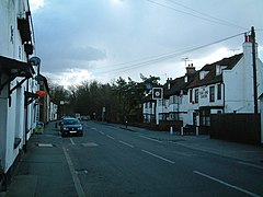
Colnbrook
| Colnbrook | |
|---|---|
 Historic and public house dominated part of the high street |
|
| Colnbrook shown within Berkshire | |
| Population | 6,157 |
| OS grid reference | SU945805 |
| Civil parish | |
| Unitary authority | |
| Ceremonial county | |
| Region | |
| Country | England |
| Sovereign state | United Kingdom |
| Post town | SLOUGH |
| Postcode district | SL3 |
| Dialling code | 01753 |
| Police | Thames Valley |
| Fire | Royal Berkshire |
| Ambulance | South Central |
| EU Parliament | South East England |
| UK Parliament | |
Colnbrook is a village in the unitary authority of Slough in Berkshire, England. It was formerly in the historic county of Buckinghamshire. It straddles the Colne Brook and Wraysbury River which join on its southwest border (two distributaries of the Colne). It is centred 3 miles (4.8 km) southeast of Slough, 8 km (5.0 mi) east of Windsor and 18 miles (29 km) west of central London.
Colnbrook is the most part of the civil parish of Colnbrook with Poyle (see also Poyle). Junctions of the M4 and M25 are near the village. To the east is Longford, London, and Bedfont and Stanwell which abut the south of London Heathrow Airport.
Colnbrook with Poyle is a suburban parish with significant industrial units, logistical premises and open land. The parish was created on 1 April 1995 as an amalgamation of Colnbrook from Iver to the north and the smaller Poyle from an unparished area of Stanwell to the south-east. At the 2011 census the whole civil parish had a population of 6,157 living in 2,533 homes.
Mentioned in William the Conqueror's Domesday Book, Colnbrook is on the Colne Brook, a tributary of the River Colne, hence Colnbrook.Coaching inns were the village's main industry. In 1106 the first one was founded by Milo Crispin, named the Hospice (now the Ostrich Inn), the third oldest in England. By 1577 Colnbrook had no fewer than ten coaching inns. Colnbrook's High Street was on the main London to Bath road and turn off point for Windsor and was used as a resting point for travellers.
...
Wikipedia

