Cody, Wyoming
| Cody, Wyoming | |
|---|---|
| City | |

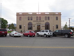
Old Cody Post Office in Cody
|
|
 Location of Cody in Wyoming |
|
| Coordinates: 44°31′24″N 109°3′26″W / 44.52333°N 109.05722°WCoordinates: 44°31′24″N 109°3′26″W / 44.52333°N 109.05722°W | |
| Country | United States |
| State | Wyoming |
| County | Park |
| Named for | William Frederick Cody |
| Government | |
| • Mayor | Matt Hall |
| Area | |
| • Total | 10.43 sq mi (27.01 km2) |
| • Land | 10.20 sq mi (26.42 km2) |
| • Water | 0.23 sq mi (0.60 km2) |
| Elevation | 4,997 ft (1,523 m) |
| Population (2010) | |
| • Total | 9,520 |
| • Estimate (2012) | 9,689 |
| • Density | 933.3/sq mi (360.3/km2) |
| Time zone | Mountain (MST) (UTC-7) |
| • Summer (DST) | MDT (UTC-6) |
| ZIP code | 82414 |
| Area code(s) | 307 Exchanges: 527,578,587 |
| FIPS code | 56-15760 |
| GNIS feature ID | 1586861 |
| Website | http://www.cityofcody-wy.gov |
Cody is a city in northwest Wyoming and the county seat of Park County, Wyoming, United States. It is named after Colonel William Frederick "Buffalo Bill" Cody for his part in the creation of the original town. The population was 9,520 at the 2010 census.
Cody is served by Yellowstone Regional Airport.
Cody is located at 44°31′24″N 109°3′26″W / 44.52333°N 109.05722°W (44.523244, −109.057109).
According to the United States Census Bureau, the city has a total area of 10.43 square miles (27.01 km2), of which, 10.20 square miles (26.42 km2) is land and 0.23 square miles (0.60 km2) is water.
Cody's elevation is about 5016 ft (1,500 m) above sea level. The main part of the city is split across three levels, separated by about 60 feet (18 m).
The Shoshone River flows through Cody in a fairly deep canyon. There are four bridges over this river in the Cody vicinity, one at the north edge of town that allows travel to the north, and one about 5 miles (8.0 km) east of Cody that allows passage to Powell and the areas to the north and east. The other two are west of town; one allows access to the East Gate of Yellowstone National Park, and the other is used by fishermen in Shoshone Canyon and as access to the Buffalo Bill Dam.
Cody is located at the western edge of the Bighorn Basin, a depression surrounded by the Big Horn, Owl Creek, Bridger, and Absaroka ranges. At the western edge of Cody, a deep canyon formed by the Shoshone River provides the only passage to Yellowstone's Eastern Entrance. At its mouth and rising above Cody are Rattlesnake Mountain on the north side and Cedar Mountain on the south side. Most of Cody has a spectacular view of Heart Mountain, whose 8,123 ft (2,500 m) peak is 9 miles (14 km) directly north of Cody, and the Carter Mountains, which form a line with peaks at about 12,000 ft (3,700 m), some 15 miles (24 km) to the south.
...
Wikipedia
