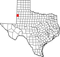
Cochran County, Texas
| Cochran County, Texas | |
|---|---|

Cattle grazing on the South Plains between Denver City and Morton
|
|
 Location in the U.S. state of Texas |
|
 Texas's location in the U.S. |
|
| Founded | 1924 |
| Named for | Robert E. Cochran |
| Seat | Morton |
| Largest city | Morton |
| Area | |
| • Total | 775 sq mi (2,007 km2) |
| • Land | 775 sq mi (2,007 km2) |
| • Water | 0.09 sq mi (0 km2), 0.01% |
| Population | |
| • (2010) | 3,127 |
| • Density | 4.0/sq mi (2/km²) |
| Congressional district | 19th |
| Website | www |
Cochran County is a county located in the U.S. state of Texas. As of the 2010 census, its population was 3,127. The county seat is Morton. The county was created in 1876 and later organized in 1924. It is named for Robert E. Cochran, a defender of the Alamo.
According to the U.S. Census Bureau, the county has a total area of 775 square miles (2,010 km2), of which 775 square miles (2,010 km2) is land and 0.09 square miles (0.23 km2) (0.01%) is water. Cochran County lies on the high plains of the Llano Estacado. The western border of the county lies along the border of Texas and New Mexico.
As of the census of 2000, there were 3,730 people, 1,309 households, and 1,017 families residing in the county. The population density was 5 people per square mile (2/km²). There were 1,587 housing units at an average density of 2 per square mile (1/km²). The racial makeup of the county was 64.48% White, 4.53% Black or African American, 0.83% Native American, 0.21% Asian, 0.05% Pacific Islander, 27.35% from other races, and 2.55% from two or more races. 44.13% of the population were Hispanic or Latino of any race.
...
Wikipedia
